Located in the Araucanía Region of Chile, the Conguillío National Park stands as a mighty testament to the splendor of nature. With the towering Llaima Volcano, serene lakes, ancient araucarias, and diverse fauna, this park attracts adventurers, nature lovers, and culture enthusiasts alike. Dive into this guide and discover the mystical beauty and vibrant traditions that await you.
Conguillío National Park Data
Content
- 1 Conguillío National Park Data
- 2 Natural Attractions and Landscapes
- 3 Biodiversity and Wildlife
- 4 Conguillío National Park Trails
- 4.1 Pastos Blancos
- 4.2 Rainbow Lagoon
- 4.3 Captrén Lagoon
- 4.4 Sierra Nevada
- 4.5 Los Carpinteros
- 4.6 Pastos Blancos
- 4.7 Contrabandista
- 4.8 Travesía Río Blanco
- 4.9 Travesía a Malalcahuello
- 4.10 Ruta al Llaima
- 4.11 Conguillio Los Paraguas
- 4.12 Sendero Cañadón Truful Truful
- 4.13 Las Vertientes
- 4.14 Las Araucarias
- 4.15 La Ensenada
- 4.16 Lan Lan
- 5 Recommended Activities
- 6 Culture and Local Communities
- 7 How to Get There: Transportation and Access
- 8 Lodging: Cabins, Campsites, and Hotels
Geographical Location
Located in the La Araucanía Region of Chile, the Conguillío National Park is about 148 km northeast of Temuco, the regional capital. The park spans territories in several communes, including Curacautín and Lonquimay in the Malleco province, and Vilcún, Cunco, and Melipeuco in the Cautín province. Its geographical location can be pinpointed by the coordinates: 38°40′00″S 71°39′00″W. This privileged location in La Araucanía grants it rich geographical diversity, with the Llaima Volcano, crystal-clear lakes, and ancient forests making it so appealing to nature and adventure lovers.
History and Designation as a National Park
Designated as a National Park on April 15, 1987, Conguillío has undergone several stages of creation and expansion. Initially established as "Los Paraguas" on August 21, 1940, covering an area of 18,750 hectares. Subsequently, on May 26, 1950, the "Conguillío Forest Reserve" was created, adding an additional 36,000 hectares.
In an effort to consolidate and expand the protection of this exceptional natural area, on October 17, 1967, the sector known as "Laguna Verde" was incorporated into the park, covering an additional 137 hectares.
Finally, in 1987, a reconstitution took place culminating in the creation of the Conguillío National Park as we know it today. In this last stage, it reached its current size, encompassing an impressive area of 60,833 hectares.
It is important to mention that in 1983, Conguillío Park was recognized as a Biosphere Reserve and was given the name "Araucarias Biosphere Reserve". This designation is a recognition of the rich biodiversity and the importance of preserving the ecosystems of this region.
The park is located in several communes, including Curacautín and Lonquimay in the Malleco province, and Vilcún, Cunco, and Melipeuco in the Cautín province, all located in the La Araucanía Region, Chile.
Climatic Conditions of Conguillío
With a variable climate ranging from alpine to temperate, this park offers a unique mix of ecosystems and landscapes. It presents two distinct climate types, according to the Köppen classification:
- Warm-Temperate with Less than Four Dry Months: this climate is found in the foothill area of the park. Average temperatures range between 15.1 °C in the warmest month, January, and 6.0 °C in June and July, the coldest months. From May to October, average minimums drop below 3 °C, resulting in frequent frosts. Precipitation in this zone ranges from 1500 to 2500 mm per year. It is important to mention that relative humidity is low in this region.
- Highland Tundra: this type of climate is found on the hilltops starting from 1400 meters above sea level. Here, water presence is mainly in the form of snow. Dominant temperatures are low and often remain below 0 °C both in winter and summer. Precipitation in this zone is more abundant, reaching 3000 mm annually. Relative humidity is also low in this area. It is noteworthy that this climate is seasonal and occurs from late autumn to mid-spring.
Conguillío thus offers a unique blend of ecosystems and landscapes due to this climatic variation. From the foothills with temperate temperatures and moderate rainfall to the hilltops with cold temperatures and abundant snowfall, the climatic diversity contributes to the rich biodiversity and scenic beauty of the area protected by the Chilean government.
Natural Attractions and Landscapes
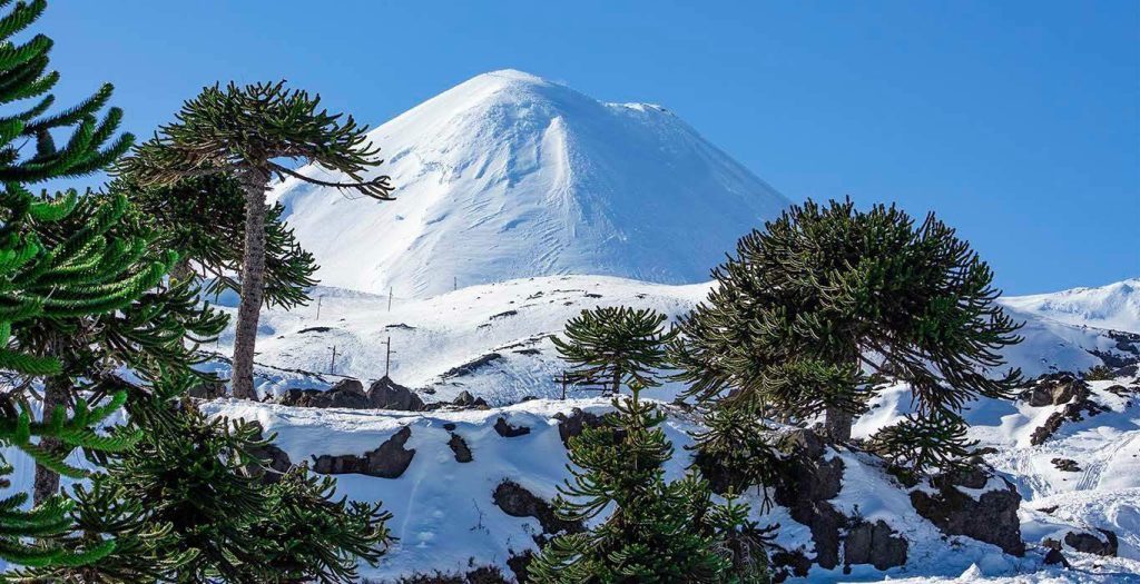
Llaima Volcano
Located in the foothill area of Conguillío National Park, it is one of the most active and voluminous stratovolcanoes in Chile and South America. It formed after Sierra Nevada, in the same Quaternary period approximately 2.6 million years ago.
With its more than 29 km² of glaciers on the western, southwestern, and eastern flanks, Llaima Volcano is a majestic and spectacular geological formation. It presents an almost perfect conical shape, with two summits and around 40 adventitious scoria cones on its surface.
Since 1994, the volcano has maintained an active fumarole emitting gases and water vapor, indicating its ongoing volcanic activity. The northern summit exhibits an open crater 350 meters in diameter and over 300 meters deep, adding to its beauty and uniqueness.
It is an impressive natural attraction that dominates the landscape of Conguillío National Park and represents a key element in the diverse and fascinating geography of the La Araucanía region in Chile.
Sierra Nevada Volcano
Stands out as the first volcanic formation in the Conguillío area. Its appearance is associated with the Quaternary period, approximately 2.6 million years ago.
This volcano is unique in several aspects. Firstly, it is considered to be of inactive and low danger nature. Unlike other nearby volcanoes, it does not show recent volcanic activity or significant threats.
What makes Sierra Nevada Volcano distinctive and distinctive is its characteristic shape. It is relatively low and wide compared to other volcanoes in the region. This morphology is due to the influence of the large ice masses that covered it during the last glaciation. Glacial action molded its structure, leaving a unique imprint on the landscape.
Today, Sierra Nevada Volcano is an important element in the diverse geography of Conguillío Park. Its inactivity and low danger make it a point of interest for visitors who want to explore and admire the traces of glacial past in this impressive protected area of the La Araucanía region in Chile.
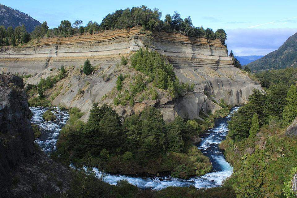
Truful Truful Canyon
It is a place of great importance, located at the southern entrance of the park. Access is through a trail that allows you to visualize the Truful Truful River at the bottom and an impressive wall 75 meters high on the other side of the river.
This wall is of great relevance for the study of the historical behavior of Llaima Volcano, as it represents about 13,000 years of eruptive history of the volcano. The pyroclastic flow, fall, and surge deposits, product of mainly Holocene explosive eruptions of Llaima Volcano, form a layered succession that can be observed on the wall.
The current soil has developed over the Truful Truful sequence, although in some areas it has been affected by alluvial flows that have locally eroded the terrain. When the place is clear, it is possible to appreciate the majestic Llaima Volcano from this location, providing an impressive view.
Regarding vegetation, Truful Truful Canyon has partial vegetation colonization, where species such as liquiñes, herbaceous, and shrubs can be found. This place is a natural gem in Conguillío Park, allowing visitors to delve into the geological history of the region and enjoy stunning landscapes surrounded by characteristic flora and fauna of the area.
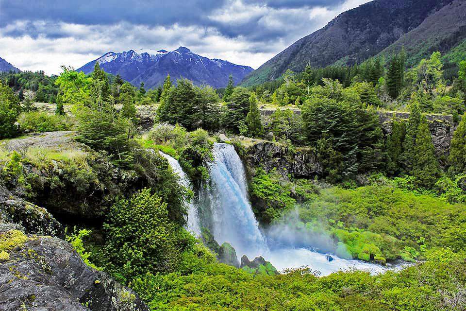
Truful Truful Waterfalls
A set of impressive waterfalls located in the upper area of the river of the same name, within the delimited area of the National Park. These falls are located in a volcanic scree surrounded by basaltic and volcanic layers that have given rise to a plateau with a cut of approximately seven meters in height, which is crossed by the river, thus generating the characteristic waterfalls.
This environment offers a unique view of the effect of the ancient glaciers that once covered the river valley. The layers of soil formed over thousands of years can be observed, which have been worn down and cut vertically due to the erosive action of the river.
The Truful Truful Waterfalls are a true natural spectacle that allows visitors to enjoy nature with the impressive force and beauty of the water plummeting from above. It is an ideal place to appreciate the geology and geological history of the region, as well as to admire the impact of water on landscape formation over thousands of years.
Mother Araucaria
Scientifically known as Araucaria araucana, it is an ancient species that dominates the landscape of Conguillío. This mighty tree stands out for its fruit known as "piñón" and can be found along most of the park’s trails.
It is important to mention that, despite its name "Mother Araucaria," this specimen is actually male, with an active annual generation of male cones that produce abundant pollen. Its name comes from its size and longevity, as it is one of the largest and oldest specimens in the area.
The Mother Araucaria is an emblematic and representative species of the La Araucanía region in Chile and is a natural treasure protected within Conguillío National Park. Its presence adds a touch of beauty and mysticism to hiking routes, captivating visitors with its majesty and its important role in the local ecosystem.
Conguillío Lake
This crystalline lake is surrounded by mountains and forests of ancient araucarias, creating an impressive scenery that attracts numerous visitors.
With a surface of tranquil waters, Conguillío Lake offers a variety of water activities and recreational opportunities to enjoy. Fishing enthusiasts find excellent opportunities to fish in its waters, while those looking to explore nature can paddle along its shores in canoes or kayaks rented at the park’s administration.
The lake is also a privileged spot for observing the fauna and flora of Conguillío National Park, with birds and other species frequenting its surroundings.
Lakes and Lagoons
Lakes and lagoons, like the famous Conguillío Lake, offer opportunities for fishing, boating, and nature contemplation.
Geological Formations and Natural Phenomena
From rock formations to natural phenomena like the Mother Araucaria, it offers a variety of geological wonders to discover.
Biodiversity and Wildlife
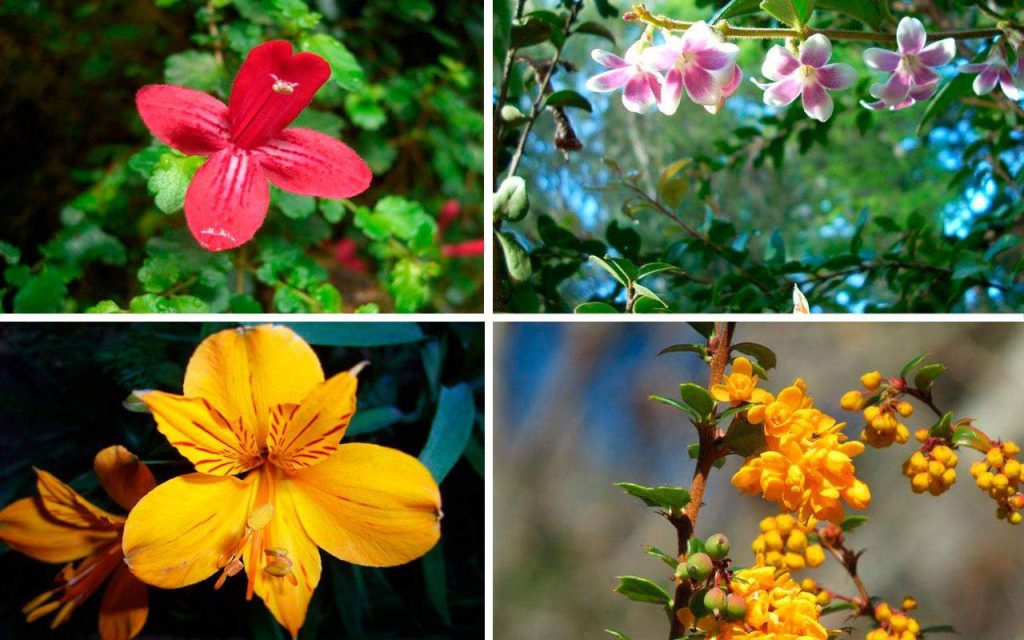
Flora: Vegetation and Endemic Species
The rich flora of the park includes endemic species and unique plants adapted to alpine and temperate conditions. Among the species of flora present are:
- Raulí (Nothofagus alpina): a deciduous tree with valuable wood that is part of the Patagonian Andean forest.
- Lenga (Nothofagus pumilio): a type of deciduous tree with high-quality wood found in subantarctic forests.
- Ñirre (Nothofagus antarctica): beech characterized by its reddish bark and presence in subantarctic forests.
- Roble (Nothofagus oblicua): evergreen beech that is part of the Valdivian forest.
- Araucaria (Araucaria araucana): one of the most iconic trees in the park, this conifer species stands out for its unique shape and appearance and is known as the "Chilean araucaria."
- Ciprés de la Cordillera (Austrocedrus chilensis): a cypress native to the Andean region, found in high-altitude areas.
- Coihue (Nothofagus dombeyi): beech that is part of the Valdivian forest and is characteristic of the southern zone of Chile.
- Wild Strawberry or Chilean Strawberry (Fragaria chiloensis): a species of strawberry native to Chile that grows in open areas and forest edges.
- Estrellita (Asteranthera ovata): a small plant with white flowers found in rocky areas.
- Liuto (Alstroemeria aurea): a plant with beautiful yellow and red flowers found in meadows and hillsides.
- Quilmay (Elytropus chilensis): a herbaceous plant with violet flowers that grows in open areas.
- Michay (Berberis darwinii): a shrub with yellow flowers and edible berries, typical of the Andean region.
- Maqui (Aristotelia chilensis): a shrub with dark-colored berries, known for its high antioxidant content and nutritional value.
The presence of these species, including the impressive araucaria forests, contributes to the rich biodiversity of the Conguillío region and the protected area known as Conguillío National Park.
Fauna: Mammals, Birds, and Other Animals
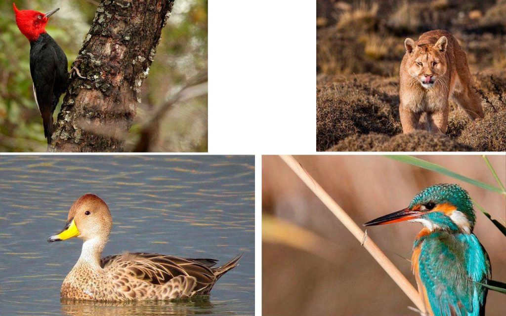
The diverse fauna, from the pudú to the black woodpecker, is a key attraction for nature lovers and photographers. This diversity is due to its location in southern Chile, in the La Araucanía Region, which offers ideal habitats for a wide variety of mammal, fish, reptile, amphibian, and bird species such as:
- Güiña (Leopardus guigna): a small species of feline that is endangered and is an important symbol of conservation in Chile.
- Degu (Octodon degus): a small vulnerable rodent that inhabits areas of dense vegetation.
- Quique (Galictis cuja): a small carnivorous mammal with a low risk status.
- Puma (Felis concolor): known as the mountain lion, it is a large feline present in the park with a low risk status.
- Pudú (Pudu): a small deer that is vulnerable and is the smallest mammal in the park.
- Mountain Viscacha (Lagidium viscacia): a nocturnal rodent that is endangered and endemic to South America.
- Valdivian Mole Mouse (Geoxus valdivianus): a small rodent with a low risk status that inhabits humid and forested areas.
- Long-haired Grass Mouse (Akodon longipilis): a small rodent in danger that inhabits wooded and humid areas.
- Culpeo Fox (Pseudalopex culpaeus): a native Chilean canid with a low risk status that inhabits various habitats.
- Chilla Fox (Pseudalopex griseus): a native canid with a low risk status that is common in the region.
Conguillío National Park Trails
You’ll find a variety of trails that can be explored both independently and with specialized guides. These trails will allow you to access different areas of the park and explore its most interesting points and unique features.
Pastos Blancos
The Pastos Blancos trail, according to conservation photographer Francisco Espíldora, is a must-visit route for hiking enthusiasts in Conguillío National Park. Covering a distance of 13 kilometers and taking approximately five hours one way, this trail offers an unforgettable experience for nature lovers.
The journey begins at the Laguna Captrén gate and offers a combination of breathtaking landscapes as you traverse the slopes of the Llaima volcano. During the hike, you can enjoy panoramic views of Sierra Nevada and Lake Conguillío. This time of year is particularly recommended, as hikes through the volcanic scoria fields are more enjoyable than in other seasons like summer.
In addition, the trail leads visitors to the beautiful Laguna Verde, a consistently captivating spot. To enhance the experience, Francisco Espíldora highlights the cozy atmosphere of the La Baita Conguillío lodge, where he had the opportunity to stay during his week-long trip to the region. According to him, this strategically located place is ideal for setting out to explore and enjoy the wonders that the park offers at this time of year.
Rainbow Lagoon
According to photographer and founder of Chile Indómito, Jean Paul de la Harpe, the Rainbow Lagoon trail is one of the richest places to appreciate autumn in all its splendor. Covering a distance of no more than 1 kilometer, this easily accessible hiking route is especially recommended for families and enthusiasts looking to immerse themselves in its scenic beauty.
What makes this trail truly interesting are the different shades that the tree species in the area acquire during autumn. Raulí, ñirre, lenga, araucarias, and coigües create a photogenic and attractive mix that contrasts with the geography of the place, creating a visually stunning experience. Additionally, the Rainbow Lagoon, formed 320 years ago due to the eruption of the Llaima volcano which dammed the waters of a stream, adds a natural mirror that further enhances the beauty of the surroundings.
The prominence of the raulí forests, which turn reddish during autumn, and the panoramic view formed by the lagoon make this trail a must-visit for any photography and nature enthusiast. It’s a unique opportunity to appreciate the magic of autumn amidst breathtaking landscapes, all in a place that’s easily accessible and with a fascinating geological history.
Captrén Lagoon
The trail bordering Captrén Lagoon is our third recommendation in Conguillío National Park. Located in the northern access of the park, this area impresses visitors with the sight of native trees submerged underwater, which are easy to observe.
For trekking and photography enthusiasts, this trail has become a favorite, especially for Javiera Zerene. She enjoys visiting and photographing the birds that inhabit the area, as Captrén Lagoon is a stopping point for various species during their migrations. Notable species include the black woodpecker, making the place an ideal birdwatching spot.
The Committee for the Defense of Flora and Fauna (CODEFF) has chosen this place several times and has held its bird festival here for several years. The short duration of the trail, approximately two kilometers, makes it ideal for families and those who want to take the time to admire the trees and fauna that make up the environment.
Additionally, the privileged view towards the Llaima volcano is another factor that makes this trail highly recommended. Visitors can enjoy breathtaking landscapes while immersing themselves in the natural beauty of Conguillío.
Sierra Nevada
Length: 10 km, Duration: Approximately 3 hours one way.
Los Carpinteros
Length: 8 km, Duration: Approximately 2.5 hours one way.
Pastos Blancos
Length: 11 km, Duration: Approximately 5 hours one way.
Contrabandista
Length: 15 km, Duration: Approximately 3.5 hours one way.
Travesía Río Blanco
Length: 5 km, Duration: Approximately 5 hours one way.
Travesía a Malalcahuello
Length: 10 km, Duration: Estimated at 48 hours.
Ruta al Llaima
Length: 8 km, Duration: Approximately 8 hours one way.
Conguillio Los Paraguas
Length: 9 km, Duration: Estimated at 10 hours.
Sendero Cañadón Truful Truful
Length: 0.8 km, Duration: Approximately 45 minutes one way.
Las Vertientes
Length: 0.8 km, Duration: Approximately 45 minutes one way.
Las Araucarias
Length: 0.8 km, Duration: Approximately 45 minutes one way.
La Ensenada
Length: 0.8 km, Duration: Approximately 45 minutes one way.
Lan Lan
Length: 0.2 km, Duration: Approximately 20 minutes one way.
Each of these trails offers a unique opportunity to explore and enjoy the stunning beauty and biodiversity of Conguillío National Park. Get ready for exciting adventures in the midst of nature!
Recommended Activities
Hiking and Trekking Routes
With trails for all levels, hiking is one of the best ways to explore the park.
Fishing and Water Activities
Fishing in the park’s lakes and rivers is a popular activity, as well as canoeing and kayaking.
Birdwatching and Wildlife Observation
Birdwatching and observing other animals is a rewarding activity that offers an intimate approach to the park’s wildlife. It can be done from various viewpoints and while walking along the different trails.
Guided Tours and Environmental Education
Guided tours and educational programs offer an enriching perspective on the ecology and culture of the area. With park guides, you can gain deeper insights to learn in detail about the different species of fauna and flora, as well as about the local indigenous populations.
Culture and Local Communities
Mapuche Traditions and Culture
The influence of Mapuche culture is palpable in the gastronomy, craftsmanship, and local festivals.
- Gastronomy: Mapuche cuisine brings authentic and traditional flavors to the region’s culinary offering. Typical dishes like catuto and piñon are part of the delicious gastronomic experience, highlighting local ingredients and ancestral preparation techniques.
- Handicrafts: The skill and creativity of Mapuche artisans are manifested in their weavings, ceramics, and wood carvings. These crafts reflect the deep connection with nature and the worldview of this indigenous people.
- Festivals: Local celebrations are a window to learn about and appreciate Mapuche traditions. In these events, music, dance, and ancestral rituals intertwine to celebrate the identity and cultural heritage of this community.
The presence of Mapuche culture in the surroundings of Conguillío National Park provides a unique opportunity to immerse oneself in the traditions and values of this ancestral people, enriching the experience of those who visit the region and seek to understand and value Chile’s cultural diversity.
Gastronomy and Local Products
Enjoy local cuisine with typical dishes like catuto, an ancestral food of Mapuche culture, which consists of roasted and ground wheat grains, which are then mixed with honey or chancaca (a type of brown sugar). This preparation results in a small sweet bread, which becomes an ideal accompaniment for many meals. Also, the piñon, an edible seed that comes from the Araucaria Araucana, the emblematic tree of the region. Piñons can be consumed raw or roasted and are a delicacy highly appreciated by both locals and visitors.
How to Get There: Transportation and Access
Accessible by road, Conguillío National Park offers several transportation options and is easily accessible from Temuco and other nearby urban centers. It can be accessed from the towns of Lonquimay or Malalcahuello. Additionally, there are several trails and internal roads that allow you to explore different sectors of the park and access its main natural attractions and landscapes.
- From the NORTH: Route 5, take the exit towards Victoria and continue on Route 181 to Curacautín. From Curacautín, take Route R-925-S, which leads directly to the park. The first checkpoint is located 30 kilometers from Curacautín on Route R-925-S.
- From the SOUTH: Route 5, take the exit towards Freire on Route 199 and then continue on Route S-61 until you reach the town of Melipeuco. From Melipeuco, take Route R-925-S, which leads to the park. From this point, it’s only 15 kilometers to the entrance.
- From ARGENTINA: After crossing the Pino Hachado pass, continue on Route 181. After 40 kilometers, you will reach the town of Lonquimay. Continue on Route 181 and 124 kilometers later, you will reach Curacautín. From Curacautín, take Route R-925-S, which leads to the park. The first checkpoint is located 30 kilometers from Curacautín on Route R-925-S.
It’s important to note that Route R-925-S closes during the winter months due to snow conditions. Therefore, it’s recommended to check the access conditions before planning a trip in winter.
Map to Reach Conguillío
Lodging: Cabins, Campsites, and Hotels
Cabins Inside the Park
Cabins within Conguillío National Park offer a unique experience to enjoy nature in a mountainous environment surrounded by the beautiful Araucaria forest. These cabins operate year-round, allowing visitors to enjoy this spectacular setting in any season.
Designed with an environmentally friendly focus, the cabins are equipped with insulation technology that keeps them warm throughout the year, providing a cozy atmosphere even in the coldest times. Each cabin is fully equipped and features wood heating, adding a traditional and welcoming touch.
A special feature of these cabins is the presence of an outdoor hot tub, providing a unique outdoor relaxation experience while enjoying the natural wonders offered by the park.
The cabins are available in two different sizes: five cabins for 7 people with an additional futon, and six cabins for 2 people with an additional futon. This variety of accommodation options allows both families and couples to enjoy a comfortable and pleasant stay in Conguillío National Park.
Campsites Inside the Park
In addition to cabins, Conguillío National Park offers visitors the opportunity to camp and enjoy nature in five camping areas within the park:
- Camping "Los Ñirres": This area has 42 camping sites and is the closest to the lake. It’s ideal for those who want to be near the water and enjoy panoramic views of Lake Conguillío.
- Camping "Los Carpinteros": With 12 camping sites, this area is located between the ñirres and Araucaria forest, providing a discreet and tranquil atmosphere. It’s located approximately 200 meters from the lake, making it an attractive option for nature lovers.
- Camping "El Estero": With 24 camping sites, this area is shared, and each site has a capacity for 6 people. It’s located along the main road, surrounded by the ñirres forest, providing a cozy and natural environment.
- Camping "La Caseta": With 10 camping sites, this area offers a more secluded and discreet experience, away from the crowds. It’s situated between the ñirres forest and the shores of Lake Conguillío, allowing campers to enjoy a quiet and serene environment.
- Camping "El Hoyón": With 10 camping sites, this area features one of the best beaches in Conguillío. It’s ideal for those who want to enjoy the beauty of the lake and relax in a stunning natural setting.
Accommodation in Nearby Towns
From campsites to cabins and hotels, there are accommodation options for all tastes and budgets. In the towns near Conguillío National Park, visitors can comfortably stay, with different services adapting to their personal preferences and budgets.
- Melipeuco: This town is located a few kilometers from the park and offers a variety of accommodations, including cabins, hostels, and small hotels. Travelers can find comfortable and cozy options to rest after a day of adventures.
- Curacautín: Located approximately 50 kilometers from the park, Curacautín is another option for staying in the area. Here, visitors can find hotels with modern amenities and full services, as well as rustic cabins with panoramic views of the surrounding nature.
- Vilcún: A town at a similar distance from Conguillío and offers a combination of accommodation options. Tourists can choose to stay in charming cabins in the middle of the forest or in comfortable hotels with modern amenities and services.
- Malalcahuello: Although it’s a few kilometers further from the park, Malalcahuello is a popular option for those who want to be surrounded by mountain landscapes and native forests. Here, tourists will find cabins and lodges with stunning views and access to a variety of outdoor activities.
- Lonquimay: Located about 60 kilometers north of the park, Lonquimay offers accommodation options including cabins, hostels, and small hotels. Visitors can enjoy the tranquility of this town and explore its surrounding nature-filled surroundings.
Best Times to Visit
Conguillío National Park is a stunning destination in the Araucanía Region of Chile. To fully enjoy this unique experience, it’s essential to choose the best time to visit the park. Below, I present information about the best times to plan your visit:
- Spring (September to November): During spring, the vegetation blooms with a variety of colors and life. It’s a good time for observing wildlife, as many species are active, and it’s possible to see migratory birds arriving in the area. Temperatures start to become more pleasant, and conditions for outdoor activities such as hiking and bird watching are ideal.
- Summer (December to February): It’s the high season in Conguillío National Park. Days are longer and warmer, allowing full enjoyment of water activities in the lakes and rivers, such as fishing and kayaking. It’s also a good time to hike the trails and explore the beauty of the forests and the volcano. However, keep in mind that during this season, there may be a higher influx of visitors.
- Autumn (March to May): Another lovely season to visit the national park. Araucaria forests and other native species acquire golden and reddish tones, creating spectacular landscapes. Additionally, the weather remains pleasant for outdoor activities. It’s a less crowded time than summer, allowing you to enjoy a quieter and more serene experience.
- Winter (June to August): It can be a challenging time for visits due to weather conditions. Temperatures are cold, and there is snow in the higher areas, which can make access to certain trails and areas difficult. However, if you’re a winter enthusiast and enjoy snowy landscapes, this season can also be attractive. You should be prepared for the cold weather and check accessibility before planning your visit.

