Manu National Park

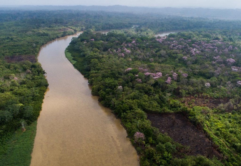
Located in the lush Amazon rainforest of southeastern Peru, the Manu National Park stretches across the Andean mountains and the Amazon jungle. It is recognized as one of the most biodiverse corners of the planet. From its towering mist-covered mountains to the dense tropical jungles that stretch along winding rivers, Manu harbors an astonishing variety of wildlife, including endangered species and indigenous communities that have inhabited these lands since time immemorial.

Description of Manu National Park

The Manu National Park, recognized by UNESCO as a World Heritage Site, offers an unparalleled experience of connection with nature. Its history, rich in biodiversity and ancestral cultures, makes it a top destination for scientific research and ecotourism. The protection of this park ensures the conservation of one of the world’s most important ecosystems.
Manu National Park
Located in southeastern Peru, the protected area known as Manu encompasses parts of the Madre de Dios and Cuzco departments, between the provinces of Manu and Paucartambo. Spanning a vast area of 1,909,806 hectares, it is divided into three main areas: the national park itself with 1,909,806 hectares, the reserved zone, and the buffer zone. It is managed by the National System of Natural Protected Areas (SINANPE) through the National Service of Natural Protected Areas (SERNANP).

From its lowest point, about 300 meters above sea level at the confluence of the Manu and Madre de Dios rivers, to its highest point at the summit of Mount Apu Kañaqway, at over 4000 meters above sea level, the park encompasses an incredible diversity of habitats and ecosystems. According to oral tradition, some unexplored areas of this reserve could harbor the legendary Paititi, the lost city of the Incas.

History of Manu National Park

The history of protection of Manu National Park dates back to 1968 when it was established as a national reserve, and later on May 29, 1973, it was officially declared a national park through Supreme Decree No. 0644-73-AG. Later, on July 14, 2002, its extension was increased by Supreme Decree No. 045-2002-AG.
The international recognition came in 1977 when UNESCO designated the park as a biosphere reserve, highlighting its ecological importance. Then, in 1987, Manu NP was declared a Natural Heritage of Humanity by UNESCO, emphasizing its exceptional value for the conservation of biodiversity and the unique ecosystems it hosts.

Ethnic and Migratory History in Manu National Park

The etymology of the name "Manu" comes from the Araona language and means ‘river’. Araona is a language belonging to the pano-tacana linguistic family, related to ese-eja spoken in the Madre de Dios basin. This data has been recorded, among others, by Father Armentia in his work "Navegación del Madre de Dios. Viaje del padre Nicolás de Armentia" published in La Paz in 1896. It coincides with what is known about toponymy in the Peruvian and Bolivian east, where names like Tahuamanu, Tacuatimanu, Pariamanu in Madre de Dios, and Manoa (meaning ‘muddy river’) in Contamana, support this explanation.
Ethnic and Migratory History in Manu National Park
In the area of Manu National Park, there are currently no traditional speakers of Araona or ese-eja. However, there are Machiguenga communities, indicating a recent migratory and territorial occupation process. These Machiguenga groups ascended through the Camisea-Mishagua-Serjali corridor and then descended through the upper course of the Manu River, a route known as the Fitzcarrald Isthmus. This settlement process occurred after the almost extinction of the Araona due to the exploitation of rubber by Bolivian and Peruvian rubber gatherers. Current Machiguenga communities, such as Palotoa, Yomibato, Tayacome, and Shipetiari, are recent settlements of nomadic groups until the late 20th century.

The presence of Yine communities has a similar explanation, also being part of more recent colonization processes. Regarding other ethnic groups such as Kirinieri and Nanti, their presence in the area is part of an even more recent colonization process, showing still nomadic behaviors.

Legacies of Manu National Park

In the Manu biosphere reserve, there are vestiges of ancient cultures, such as the enigmatic petroglyphs of Pusharo, a set of engravings whose origin and meaning have not yet been fully explained. These engravings were first reported by Father Vicente de Cenytagoya in 1921 and are located on the right bank of the Shinkibenia River, a tributary of the Palotoa River. Other petroglyphs are found in the Q’eros River, on the towering cliff Xinkiori, considered legendary by the Huachipaeris. Additionally, there is knowledge of an archaeological site in the Mameria area, located in the headwaters of the Piñi Piñi and Alto Tono rivers.

The history of Manu is marked by the arrival of people from ancient times, from the time of the Inca Empire, when the Incas Pachacútec and Túpac Yupanqui integrated this region into their vast empire, to the arrival of the Spaniards after the conquest of Cuzco. The Spaniards founded the town of Paucartambo, where they established haciendas and encomiendas, and where King Charles III of Spain ordered the construction of a bridge to facilitate the trade of local products. This was how this valley began to provide Cuzco with products such as coca, sugar, cotton, chili, wood, among others.

In March 1567, the Spaniard Juan Álvarez Maldonado, in charge of the province of Mojos, began a thirty-seven-day journey from Paucartambo to the present-day town of Pillcopata. In May of the same year, Manuel de Escobar led a second expedition that followed the course of the Madre de Dios River to the Manu River.

Historical Transformations

In 1861, Colonel Faustino Maldonado led an expedition from Paucartambo to the Madre de Dios River. Thirty years later, in his honor, the rubber baron Carlos Fitzcarrald would name the mouth of the Tambopata River Puerto Maldonado, which today is the capital of the Madre de Dios department.
In the lower jungle, indigenous communities were affected by extractive activities in the late 19th century, especially by rubber exploitation, which was initiated by entrepreneurs like Fitzcarrald, one of the most well-known rubber gatherers of the time. Although the Manu area was partially exploited, rubber activities ceased in the twenties due to overexploitation and competition with more profitable crops in Asia.

Between the 1950s and 1960s, the construction of the final stretch of the road, now known as the southern Interoceanic highway, led to the extraction of cedar and mahogany wood, the creation of haciendas, and later, the hunting of animals for fine furs such as jaguars, ocelots, and river otters. Later on, oil exploration activities began. On the other hand, in the Andean region, agricultural activities were affected by the agrarian reform of 1969.

From the 20th century onwards, religious influence became more relevant. In 1902, the Dominican fathers established their first mission in Asunción. Then, in 1908, they founded the second mission, San Luis del Manu, at the mouth of the Manu River. Later, after abandoning this place, they moved to the Palotoa River mission, in the Pantiacolla area. However, due to a flood that destroyed the mission, they settled permanently in Shintuya in 1958.

Creation and Recognition of Manu National Park

In 1963, the Manu National Forest was established. The idea of creating a national park in the area arose in 1965, based on the suggestion of Flavio Bazán and Paul Pierret, an expert from the FAO (Food and Agriculture Organization of the United Nations). The importance of the area was supported by the 1966 report prepared by British advisor Ian Grimwood. Finally, in 1968, the area was designated as a national reserve, and Manu National Park was officially established on May 29, 1973, through Supreme Decree 0644-73-AG. The main purpose of this creation was to preserve the valuable natural and cultural heritage of the area for present and future generations.

The international recognition of the area’s importance came with the designation of the Manu Biosphere Reserve by UNESCO, which covers an area of 1,881,200 hectares in the provinces of Paucartambo in Cuzco and Manu in Madre de Dios. The boundaries of this reserve were established following the principle of natural boundaries and the dominance of hydrographic basins. However, the boundary of the National Park on the Manu River had to stop at the confluence with the Panagua River due to oil exploration activities in the area.

Geographical Location

Located between the divisions of Madre de Dios and Cuzco. It extends across the Manu Province in Madre de Dios and the Paucartambo Province in Cuzco of Peru. Its geographical coordinates are 12°08′S latitude and 71°40′W longitude.

Sectors of Manu National Park

The distribution of Manu NP is divided into three main zones:

Core Zone or Manu National Park

This area is dedicated exclusively to protection, and only activities of anthropological and biological research are allowed, limited to the observation of life and ecological processes in their natural state. The Cocha Cashu Biological Station, one of the most important research centers in tropical forests, is located in this zone. Access to this area is restricted, and special authorization is required to visit.

Reserved Zone of Manu

This area is located in the lower part of the Manu River. Here, organized tourist activities by authorized agencies are allowed, as well as research with minimal manipulation. Visitors can enjoy a wide variety of natural landscapes and observe the richness of flora and fauna from the rivers and cochas (lagoons formed by river meanders). Visits are controlled and extend from the Panagua River gorge to Boca Manu.

Buffer Zone or Cultural Zone

This area comprises the banks of the Madre de Dios River and the high Andean territories bordering the southern part of the reserve, between the boundary line of the national park and the Mapacho River. Here, populations of settlers engaged in agricultural, livestock, and forestry activities predominate, and have basic health, education, and development services, albeit in an incipient manner.

In addition to these areas, around the Manu Biosphere Reserve, there are other reserves and territories such as the Kugapakori, Nahua, Nanti and others Territorial Reserve, the Megantoni National Sanctuary, and the Amarakaeri Communal Reserve. These territories, along with the Mapacho River basin and the proposed expansion of the current cultural zone, are being considered for integration into the Manu Biosphere Reserve.

Geography of Manu

The geography of Manu National Park encompasses a wide range of ecosystems, from high punas at 3500 meters above sea level, where grasslands predominate and temperatures vary considerably, to the low Amazon rainforest at about 300 meters above sea level.

The transition from high punas to low jungle begins with a strip of bushy scrubland, descending to approximately 2600 meters above sea level. Here, the vegetation gradually transforms into a forest where around 450 species of plants have been identified, and rainfall can reach between 500 and 1000 mm.

At altitudes between 2200 and 1650 meters are the low montane forests, where trees up to 25 meters high are covered by a great diversity of orchids and ferns. These mist-wrapped forests have a cold and humid climate, with a constantly shady landscape.

The area of rainy montane forest, also known as cloud forest, extends from 600 to 1650 meters above sea level. Here, lush vegetation includes trees up to 30 meters high, covered with orchids and ferns, and dotted with small streams and waterfalls. This zone harbors a wide diversity of trees, with a density that can exceed seven hundred per hectare, and has an average temperature between 20 and 25 °C.

In the low Amazon rainforest, which extends from 300 to 600 meters above sea level, the landscape is characterized by the presence of the Manu River and tall trees, such as the shihuahuaco and lupuna. This area is the most representative and extensive of the park.

Manu Park is located in the provinces of Manu and Paucartambo, in the departments of Madre de Dios and Cusco respectively. It is home to human populations of Amazonian natives, as well as a small Quechua population in the Callanga area.

Climate in Manu

The climate in Manu National Park exhibits considerable variability, generally characterized by being very rainy. The amount of precipitation varies significantly with altitude. In the southern zone, which is the highest, an annual average of 1500 to 2000 mm of rainfall is recorded. In the middle sector, this figure increases to 3000 to 3500 mm annually. However, the highest record of rainfall is found in the northwest sector, where it exceeds 8000 mm annually.

During the dry season, which occurs from May to September, rainfall decreases and temperatures drop. The thermal regime also shows significant variations, as the Amazonian zone is warm, with an average annual temperature of 25.6 °C, while the Andean zone is much colder, with an average annual temperature of 8 °C.

Biodiversity and Cultural Sanctuary

Flora and Fauna of Manu in Peru
Located in the Manu River basin, spanning areas of the Cusco and Madre de Dios regions. This park is a protected natural refuge that harbors exceptional biodiversity, recognized worldwide and preserved from human impact. It not only safeguards a wide variety of flora, ranging between 2,000 and 5,000 different species, and a diverse fauna with over 2,000 species, including endangered ones like the Andean mountain cat, but also protects cultural values rooted in the ways of life of indigenous communities that have inhabited this Amazonian region for centuries. Many of these communities have maintained voluntary isolation, without contact with the outside world, and their ways of occupying the territory have been uniquely adapted to the natural environment.

Flora and Plant Species

Manu National Park is recognized as one of the most biodiverse regions in the world, with an exceptional variety of ecological floors found in the Amazon. This diversity makes it one of the most valuable protected areas. Up to 250 species of trees have been recorded in a single hectare in this biosphere reserve. Among the most prominent flora species are cedar, cetic, screw, chestnut, lupuna, and rubber trees.

Fauna and Diversity of Animal Species

Manu National Park harbors an impressive diversity of fauna. 223 species of mammals and 1005 species of birds have been recorded in the Manu biosphere reserve, establishing world records for the diversity of amphibian species (155) and reptiles (132) in a protected area.
Amazon capybaras in Manu, Peru
Among the mammals present in the park are the jaguar, oncilla, tapir, collared peccary, deer, river otter, capybara, white-bellied spider monkey, black spider monkey, woolly monkey, howler monkey, and tamarin, among others. Additionally, it is estimated that there are around thirty million species of insects in the region, including more than 1300 species of butterflies, 650 species of beetles, 136 species of dragonflies, and over 300 species of ants.

Hoatzin in Manu, Peru

Activities and Main Tourist Attractions

From hikes through hidden trails to birdwatching and wildlife spotting, Manu offers unforgettable adventures. The activities are designed to minimize impact on the ecosystem, allowing visitors to enjoy nature responsibly.

High Andean Sector: Acjanaco – Tres Cruces

Reaching 3650 meters in altitude, this sector offers views of the puna and cloud forest, home to unique species of flora and fauna such as orchids, bromeliads, spectacled bears, pumas, and colorful birds. Around the Acjanaco checkpoint and Tres Cruces viewpoint, visitors can hike to enjoy stunning landscapes. From the Tres Cruces viewpoint, especially between the months of June and August, one can witness the sunrise, a phenomenon that attracts hundreds of people during the winter solstice. Access to this area is via a 13.5 km road from the Acjanaco Checkpoint, which is the visitor registration point for entry into the Park through the high Andean zone.

Historical and Cultural Zone

Located in the Palotoa River basin, at about 500 meters altitude, this area is famous for the enigmatic "Petroglyphs of Pusharo," figures carved into huge rocks representing one of the most important rock art manifestations in the Peruvian Amazon. Access to this area begins on the Upper Madre de Dios River, from the towns of Atalaya, Santa Cruz, and Shintuya. In the area, there is a tourist lodge managed by the native community of Palotoa – Teparo, near the petroglyphs.

Río Manu Sector

This sector extends between the Limonal and Pakitza Checkpoints, at an altitude of around 300 meters. Along the Manu River, it is possible to spot jaguars, riverside birds, turtles, and macaws, among other species. Cochas, which are lagoons inhabited by river otters, black caimans, and diverse birdlife, stand out. Additionally, the forest associations along the riverbanks are another attraction, with trees reaching heights of over 40 meters and a remarkable variety of flora and fauna. The collpas, which are walls with a high concentration of salts and minerals, are also places of interest where a great diversity of fauna can be observed.

Hiking and Trekking Routes in Manu

Route I: Cusco – Paucartambo – Acjanaco – Tres Cruces

From Cusco to Paucartambo takes approximately 3 hours by land. Then, from Paucartambo to the Acjanaco Checkpoint, it’s about a 40-minute drive by car. Finally, from the Acjanaco Checkpoint to Tres Cruces takes around 20 minutes by land.

Route II: Cusco-Atalaya – Santa Cruz – Pusharo

The journey from Cusco to Atalaya, passing through Atalaya, takes about 9 hours by land. From Atalaya to Santa Cruz, the river journey takes approximately 2 hours. Then, from Santa Cruz to Pusharo takes around 3 hours by river.

Route III: Cusco – Atalaya – Manu River

The route from Cusco to Atalaya takes around 9 hours by land. From Atalaya to the Manu River, the journey by river and land takes approximately 6 hours.

Route IV: Cusco – Manu Aerodrome (Diamante Community) – Manu River

The journey from Cusco to the Manu Aerodrome, located in the Diamante Community, takes approximately 40 minutes by air. From the Manu Aerodrome to the Manu River (Limonal Checkpoint), the river journey takes around 30 minutes.

Indigenous Cultures in Manu

Indigenous populations of the Manu National Park

Manu National Park and its surrounding area, the Manu Biosphere Reserve, exhibit remarkable cultural diversity. While the highland region is inhabited by Quechua peasant communities, the Amazonian zone is home to various indigenous peoples such as the Matsigenkas, Yines Harakmbut, Yoras (Nahuas), Nantis (Kugapakori), and the "Mashco Piro," some of whom still remain in voluntary isolation or have initial contact with the outside society.

In the Andean region, the protected area of Manu borders several Quechua Peasant Communities such as Mendozayoc, Pucará, Solan, Televan, Sahuay, Jesús María, Lali, Patanmarca, Lucuybamba, Huaccanca, Pilco Grande, Pasto Grande, and Jajahuana. The park engages with these communities through agreements on pasture use, protection of the Andean bear, and prevention of forest fires. Additionally, cultural events such as IntiPaqareq and the Virgin of Carmen, with their magical-religious significance, attract faithful and tourists to the Tres Cruces area, within the park, to witness the spectacular sunrise.

On the other hand, SERNANP has implemented the use of a commercial seal to identify products from communities and population centers within the Biosphere Reserve, as part of the updating process, resulting in the Biosphere Reserve brand.

In the Amazonian zone, Manu borders various indigenous communities such as Santa Rosa de Huacaria, Palotoa Teparo, Shipetiari, Isla de los Valles, and Diamante. Within the park are the Native Communities of Tayakome and its annex Mayzal, as well as Yomibato and its annex Cacaotal. Additionally, along the park’s territory, there are Matsigenka populations in initial contact and Mashco Piro populations in voluntary isolation. The conservation priority of ecosystems in the park ensures the provision of ecosystem services to maintain the living conditions of these populations.

The uniqueness of hosting populations within its boundaries has allowed overcoming unique challenges in its management and administration. All communities are linked through the Management Committee of the Protected Natural Area (ANP) and collaborate as allies in park management.

Sustainable Tourism in Manu National Park

The importance of tourism in Manu National Park is fundamental for the community, as it provides both direct and indirect employment opportunities, contributing to the economy and social fabric of the region. Among the touristic activities available in the park are camping in the lower basin of the Manu River, with five designated areas for this purpose, as well as visits to three viewpoints or spurs and an eighteen-meter-high metal tower in Cocha Otorongo, from where visitors can enjoy a panoramic view of the vast green horizon of the park. Other popular activities include hiking, boat trips along rivers and streams to observe diverse wildlife, as well as birdwatching. The Manu Route is famous worldwide for its great diversity of birds.

The tourism practiced in the area focuses on nature and culture, allowing tourists to immerse themselves in these environments. The diversity of flora and fauna is one of the main motivations for visitors. Additionally, sustainable development tourism is promoted in the park, seeking a balance between environmental conservation and the well-being of the local population. Therefore, environmental policies involving the community and visitors are implemented to raise awareness about the importance of conservation.

Manu National Park receives around 2500 tourists annually, with 85% of them being foreigners, making it one of the main attractions of the National Parks of Peru, mainly because it is specialized tourism that entails significant costs, according to Pedro Gamboa, head of the National Service of Natural Protected Areas by the State (SERNANP).

How to Get to Manu in Peru

Visiting Manu requires careful planning, from choosing the best time of year to how to get there. Following accommodation and local guide recommendations maximizes the visitor’s experience and ensures minimal impact on the environment.

How to Get to Manu from Cuzco

From the city of Cuzco, you must travel approximately 280 km along the Cusco-Paucartambo road, which can take about 12 hours by car, until you reach the town of Atalaya. From there, you continue by river to the town of Boca Manu, a journey that takes about 12 hours by boat. You can also choose to fly to the town of Boca Manu from the city of Cuzco, which takes about 30 minutes. From Boca Manu, you follow the route described above.

In the district of Paucartambo, you can access the Tres Cruces park sector, one of the only two places in the world where you can observe the natural phenomenon of sunrise. To reach this natural viewpoint, you must depart from the Paucartambo district to the Acjanaco Control Post of Manu National Park, in a journey of approximately half an hour by land. Then, you will take another half-hour walk to Tres Cruces, where you can enjoy the most beautiful sunrise in the world, and then continue along the route to the park.

How to Get by Bus from Cuzco

You must go to the San Jerónimo control in Cuzco. From here, combi vans depart at 11 a.m. or 5 p.m. bound for Pilcopata, which is within the cultural zone of Manu. The combi van journey takes approximately 7 hours. You also have the option of taking the combi van directly to Salvación, which is one hour further from Pilcopata. The price for the first leg is 30 soles per person, and to Salvación, it is 40 soles per person.

How to Get to Manu from Puerto Maldonado

To get to Manu from Puerto Maldonado, first, you must travel approximately 140 km along the interoceanic highway to the populated center of Santa Rosa, which takes about 1 hour and 30 minutes by car. Then, you will have to cross the Inambari River by boat to reach Puerto Carlos, which takes about 5 minutes. Afterward, you travel about 30 km by road to the town of Boca Colorado, which will take approximately 1 hour. Finally, you navigate along the Madre de Dios River until you reach the Limonal control post on the Manu River, a journey that can take about 7 hours by boat.