Loch Lomond and The Trossachs National Park, located in Scotland, encompasses the impressive Loch Lomond, as well as the hills and valleys of the Trossachs, along with other mountain ranges. It is one of the two Scottish national parks established by the Scottish Parliament in 2002, the other being the Cairngorms National Park. This park covers an extensive area in the Southern Highlands, north of Glasgow, and features numerous mountains and lakes. It is the fourth largest national park in the British Isles, covering an area of 1,865 km² and with a boundary of approximately 350 km in length. Within its territory are 21 Munros and 20 Corbetts, including notable peaks such as Ben Lomond, Ben Lui, Beinn Challuim, Ben More, and two summits called Ben Vorlich.
The park spans both sides of the Highland Boundary Fault, which divides it into two regions with different geological characteristics, soils, and topographies. This division is evident when observing Loch Lomond, crossed by the fault, where green fields and farmlands are found to the south, while mountains dominate the north.
Located near the densely populated Central Belt of Scotland, Loch Lomond and The Trossachs National Park has long been a popular destination for visitors. Its main attractions include landscape and wildlife observation, hiking, climbing, water sports, and other outdoor activities. In 2017, the park received 2.9 million visits, most of which were day trips, although there was also a considerable number of overnight visitors.
Content
- 1 Creation of the National Park Loch Lomond and The Trossachs
- 2 Geography of Loch Lomond and The Trossachs
- 3 Fauna and Flora of Loch Lomond and The Trossachs
- 4 Towns and Villages within the National Park
- 5 Munros of Loch Lomond and The Trossachs
- 6 Recommended Hikes and Activities
- 7 What to See and Do in the Nature of Loch Lomond and The Trossachs
- 8 Recommended Viewpoints
- 9 Lochs that Form the National Park
- 10 Visiting Nearby Towns and Villages
- 11 Waterfalls within the park
Creation of the National Park Loch Lomond and The Trossachs
Although many countries have created national parks to preserve wilderness areas, Scotland lacks such zones due to a long history of human activity that has modified the landscape. Settlements, agriculture, historical deforestation, overgrazing by sheep and deer, and extensive planting of introduced trees, mostly conifers, have resulted in landscapes that could be better described as semi-natural.

However, throughout the 19th and early 20th centuries, the idea emerged to designate remote or wild areas in Scotland to protect the environment and facilitate public access. After World War II, a committee was created to consider the establishment of national parks in Scotland. In 1945, five areas were proposed for this designation, one of which included Loch Lomond and The Trossachs. Although these areas were designated as "National Park Direction Areas," they did not obtain full national park status. Later, in 1981, these areas were replaced by national scenic areas.
In 1990, the Scottish Rural Commission recommended that four areas, including Loch Lomond and The Trossachs once again, should be designated as national parks due to the pressure on their landscape and heritage value. Despite these recommendations, no actions were taken until the creation of the Scottish Parliament in 1999. Finally, Loch Lomond and The Trossachs National Park was established under the National Parks (Scotland) Act of 2000, being one of the first laws passed by the Scottish Parliament. The park was officially established on July 1, 2002.
Geography of Loch Lomond and The Trossachs
Loch Lomond and The Trossachs National Park covers a large area in the western part of the Southern Highlands, north of the Glasgow conurbation. It is divided into four main sections: Breadalbane, Loch Lomond, The Trossachs, and Cowal.
Loch Lomond is the focal point of the park, being the largest lake in Great Britain with a surface area of 71 km². Surrounded by hills, including the prominent Ben Lomond to the east, it is a very popular leisure destination and is dotted with numerous islands, with Inchmurrin being the largest in the British Isles.
The Trossachs, east of Loch Lomond, are a region of wooded hills, glens, and lochs. Originally, the term referred to a small wooded area but now encompasses a wider region. It is a popular tourist destination, offering typical Highland landscapes, with its forests being an important habitat for wildlife.
Breadalbane, north of the park, includes villages such as Crianlarich and Tyndrum, characterized by rugged mountains, with Ben More being the highest in the park. Historically, Breadalbane was part of one of Scotland’s traditional provinces, encompassing the Tay River basin.
The westernmost part of the park covers the eastern side of the Cowal peninsula, separated from the rest by Loch Long. Much of this area is covered by the Argyll Forest Park, with the Arrochar Alps being a highlight for hiking and climbing, offering panoramic views of Loch Lomond.
Several important routes cross the park, including the A82 road connecting Glasgow with Fort William and the A85 passing east of the Trossachs, joining the A82 at Crianlarich. The West Highland Line railway follows the eastern shore of Loch Long to Arrochar, then connecting with the A82 towards Tyndrum.
Fauna and Flora of Loch Lomond and The Trossachs
Loch Lomond and The Trossachs National Park is home to a remarkable diversity of wildlife, with more than 200 species of birds and over 25% of all known plant species in Great Britain. Many of these species are closely associated with the Scottish Highlands, such as the capercaillie, deer, red squirrel, Scottish wildcat, golden eagle, peregrine falcon, buzzard, and osprey. Additionally, beavers have been recorded in the park, with activity observed in Loch Achray in the Trossachs. There is also an unusual colony of wallabies on Inchconnachan Island in Loch Lomond, present since the 1940s.
The park hosts a variety of habitats, including extensive forests covering approximately 30% of the area. About 22.5% is occupied by commercial conifer plantations, while native woodlands make up 7.5%. These native woodlands include Atlantic oakwoods, Caledonian pinewoods, and wet woodland areas. Additionally, important highland habitats such as heathlands, peatlands, and willow scrub are found within the park. The park features 22 large lochs and 50 major rivers and streams, as well as numerous smaller lochs, ponds, and burns, which provide habitats for various fish species including salmon, trout, and lamprey.
The park’s coastline stretches for 63 kilometers around three sea lochs: Loch Long, Loch Goil, and Holy Loch. This coastline consists of rocky cliffs, salt marshes, and mudflat areas, rich in marine invertebrates and habitat for a variety of wading and seabirds. Beyond the coast, marine species such as seals and porpoises can be found.
Towns and Villages within the National Park
Within Loch Lomond and The Trossachs National Park are various towns and villages that add distinctive character to the region. According to the 2011 census, the total population of the park was 15,168 people.
In the Stirling Council area, we can find localities such as Aberfoyle, Balmaha, Brig o’ Turk, Callander, Crianlarich, Croftamie, Drymen, Inversnaid, Killin, Lochearnhead, Port of Menteith, Tyndrum, Strathyre, Balquhidder, Kilmahog, Gartmore, and Inchmahome (island on Lake Menteith).
In the West Dunbartonshire Council area, notable villages include Balloch and Gartocharn.
In the Perth and Kinross Council area, we find the locality of St. Fillans.
And in the Argyll and Bute Council area, there are various towns and villages, including Ardentinny, Ardlui, Arrochar, Blairmore, Carrick Castle, Glenbranter, Kilmun, Lochgoilhead, Luss, Tarbet, Succoth, Strone, and Whistlefield.
These communities, each with their own charm and unique character, form an integral part of the landscape and life within Loch Lomond and The Trossachs National Park.
Munros of Loch Lomond and The Trossachs
Within Loch Lomond and The Trossachs National Park, there are a total of 21 Munros, which are mountains with a height over 914 meters (3000 feet). Most of these Munros are found in the Breadalbane section of the park. Below is a list of the Munros within the park, along with the nearest village to each:
| Munro | Height (m) | Height (ft) | Nearest Village |
|---|---|---|---|
| Ben More | 1,174 | 3,852 | Crianlarich |
| Stob Binnein | 1,165 | 3,822 | Crianlarich |
| Ben Lui | 1,130 | 3,707 | Tyndrum |
| Cruach Ardrain | 1,046 | 3,432 | Crianlarich |
| Ben Oss | 1,029 | 3,376 | Tyndrum |
| Ben Challum | 1,025 | 3,363 | Tyndrum |
| Beinn Ime | 1,011 | 3,317 | Arrochar |
| Beinn a’ Chroin | 995 | 3,264 | Crianlarich |
| Ben Vorlich | 985 | 3,232 | Lochearnhead |
| Ben Dubhchraig | 978 | 3,209 | Tyndrum |
| An Stuc | 975 | 3,199 | Lochearnhead |
| Ben Lomond | 974 | 3,196 | Balmaha |
| Meall Glas | 959 | 3,146 | Crianlarich |
| Beinn Tulaichean | 945 | 3,100 | Crianlarich |
| Ben Vorlich | 943 | 3,094 | Ardlui |
| Beinn a’ Chroin | 940 | 3,084 | Crianlarich |
| Ben Chabhair | 933 | 3,061 | Ardlui |
| Beinn Narnain | 926 | 3,038 | Arrochar |
| Sgiath Chuil | 921 | 3,022 | Crianlarich |
| Beinn a’ Chleibh | 916 | 3,005 | Tyndrum |
| Ben Vane | 915 | 3,002 | Ardlui |
Recommended Hikes and Activities
What to See and Do in the Nature of Loch Lomond and The Trossachs
Inchcailloch
Inchcailloch is part of the Loch Lomond National Nature Reserve and is a wonderful destination to explore due to its rich natural and cultural heritage. It offers the opportunity to experience solitude and wild nature in a safe and accessible environment year-round, weather permitting.

Each season brings something unique to discover. In spring, the island is adorned with bluebells, creating a magical setting for the wildlife that inhabits it. In summer, the place is full of life with a rich diversity of birds, flowers, and plants. During autumn and spring, migratory birds find refuge on the island.
Most visitors come seeking tranquility and natural beauty, and many consider the view from the summit to be one of the best in Scotland. Inchcailloch is a haven of natural beauty and wildlife waiting to be explored.
At the southern end of the island, in Port Bawn, there is a small campsite open from March 1st to September 30th.
Interesting Facts
- Inchcailloch means "island of the old woman or hooded woman".
- The highest hill on the island is called Tom na Nigheanan, which means "hill of the daughter".
- In the 8th century, Saint Kentigerna, an Irish missionary, settled on the island and is said to have founded a convent here.
Trails
Once on Inchcailloch, there are three trails that can be enjoyed individually or in combination. Each trail takes between 30 and 45 minutes to complete, so take your time to enjoy the views.
- Central Trail: This is the most direct route from the north pier to Port Bawn and takes about 20 minutes.
- Low Trail: A gentle walk through the forest with some slopes and steps. Although the forest appears untouched, it has actually been shaped by human hands to create a habitat for wildlife.
- Summit Trail: More challenging, with a steep climb to the top of the island. From here, you can appreciate how nature has sculpted the island and created various habitats for plants and animals.
Dark Skies

Dark skies are an exceptional feature of Loch Lomond and The Trossachs National Park, adding a unique dimension to the landscape experience. In these rural areas, free from the light pollution of cities, we can enjoy a clear and sharp view of the sky, where even the Milky Way can be seen stretching across the sky.
These places offer a special experience, enhancing our perception of the landscape and increasing our connection with nature. Additionally, dark skies are crucial for preserving natural nocturnal habitats, providing a valuable environment for wildlife.
To enjoy this experience, it is necessary to move away from direct street lighting and look for places with good visibility, away from buildings or trees that may obstruct the view. Once there, simply looking up on a clear night can reveal an impressive spectacle of stars and constellations.
If you want to delve deeper into stargazing, there are several local astronomical organizations that offer talks, events, and observation sessions, such as the Stirling Astronomical Society, Helensburgh Astronomical Society, Dark Sky Scotland, International Dark Sky Places, British Astronomical Society, and International Dark Sky Places. Additionally, the Dark Sky Discovery Sites network provides a list of places across the country that offer excellent night sky views and are accessible to everyone.
Breadalbane
Breadalbane, in the northern part of the National Park, is an extensive region of hills and high mountains that rise abruptly from the glen floors. In these higher areas, snow persists until early summer in the north-facing gullies and ravines.
If you enter the park from Killin, I recommend exploring the head of Loch Tay. You might be lucky enough to spot an otter if you visit early in the morning or at dusk. You can also enjoy the presence of butterflies in the sunny clearings along the old railway line.
Continuing south along Glen Ogle, why not explore Loch Earn? Here, during the summer months, you can witness ospreys fishing in the loch and hear the chirping of swifts in the settlements of Lochearnhead and St. Fillans. The woods surrounding the southern side of the loch are another excellent spot for observing red squirrels. If you decide to climb Ben Vorlich, be cautious of deer, especially during the rutting season in autumn, as their roars echo eerily through Glen Ample.
If you venture through Glen Dochart, you may spot lapwings in early summer or hear the haunting call of the curlew in the lower hills. I recommend stopping at Dalrigh and walking through the community woodlands of Strathfillan and along the River Cononish, where you can observe dippers feeding by the water.
Cowal

Cowal, located in the western sector of the park, encompasses remote areas of high hills, as well as the sea lochs of Loch Long, Loch Goil, and Loch Eck, along with the dense forests of Argyll Forest Park.
If you decide to travel along the coast to Ardentinny, you might spot porpoises, seals, or seabirds like guillemots and gannets, or explore the rock pools for crabs and sea anemones.
A recommended stop is Puck’s Glen, where you can discover an enchanted forest with its damp, shadowy understory of ferns and mosses. Glenbranter, also part of Argyll Forest Park and near the northern end of Loch Eck, offers a network of marked trails that allow you to walk among mighty oak forests or cycle through conifer plantations. Wildlife is abundant here, with the possibility of spotting crossbills high in the pines and red squirrels, especially early in the morning or at dusk.
Further north, in the hills around Arrochar, you might be lucky enough to witness the flight of a golden eagle over the mountain peaks, as well as spotting deer on the slopes.
Loch Lomond
Loch Lomond, with its vast expanse of water and landscape, is an exceptional place for wildlife observation. In addition to the loch itself, it features more than 20 islands, many of which are forested.

If you enter the National Park from the south, the National Park Visitor Centre in Balmaha is an excellent starting point for exploring Loch Lomond. Here you can learn about the landscape formation over 400 million years ago, which created the diversity of habitats between the south and north of the park.
Walking along the Millennium Forest Trail will allow you to discover more about the Atlantic oak forests surrounding the loch. May is a fantastic time to visit the eastern side of Loch Lomond, when the forest floor is covered with bluebells and wildflowers. During the ascent to Conic Hill, you can spot red squirrels in the conifers at the start of the trail, as well as birds of prey, including buzzards and hen harriers, in the open summit area.
Inchcailloch Island, just a five-minute ferry ride away, is worth a visit. Here, birdlife is abundant in summer, with species such as blackcaps, willow warblers, and chiffchaffs. You can also spot fallow deer that inhabit the island.
Further north near the loch is Cashel: the Millennium Forest Project. Several trails will take you through the native forest, where you might spot reptiles like adders, slow worms, and common lizards basking on the path edges. Access to Ben Lomond, the southernmost Munro in the National Park, is from Rowardennan. In autumn, you can hear the roaring of red deer during the rutting season or spot a ptarmigan camouflaged among the rocks near the summit.
South of Loch Lomond, near the village of Gartocharn, is the RSPB Loch Lomond Reserve. This reserve is a mix of woodland and wetlands that host a wide variety of species. In summer, you can observe migrants like redstarts and warblers, while in winter you can see Greenland white-fronted and pink-footed geese.
On the western shore of Loch Lomond, the West Loch Lomond cycle path follows the Drovers’ route from Balloch to Tarbet in the Highlands. Along the way, you might see owls hunting at dusk and keep an eye out for kingfishers and dippers at the rivers flowing into the loch from the western hills.
Trossachs

The Trossachs, located in the eastern part of the National Park, represent a transition between pastoral lowlands and the rugged Highlands. This landscape is dotted with beautiful lochs and forests, offering a great diversity of wildlife to explore.
From the settlement of Aberfoyle, you can follow the Duke’s Pass towards Callander. Near Aberfoyle, the Lodge Forest Visitor Centre offers excellent views of Queen Elizabeth Forest Park and is an ideal spot for wildlife watching. In the nearby forest, there is an easily accessible hide where you can observe red squirrels, great spotted woodpeckers, and blue tits. Additionally, the center has live CCTV footage showing ospreys, red squirrels, and water voles.
The Great Trossachs Forest NNR is a forest regeneration project aimed at creating a large-scale forest for the benefit of wildlife and people. Here, you can discover a wide range of wildlife, including black grouse, golden eagles, ospreys, pine martens, red squirrels, and otters. For more information about the project and visiting sites, as well as to learn more about the wildlife, you can visit the Great Trossachs Forest website.
Lake of Menteith, east of Aberfoyle, is another highlight for wetland bird watching. You can take a short seven-minute ferry ride to Inchmahome Priory, located on a small wooded island. Here, you can discover a number of veteran trees and, during the summer months, even witness ospreys hunting in the shallow waters of the loch.
Recommended Viewpoints
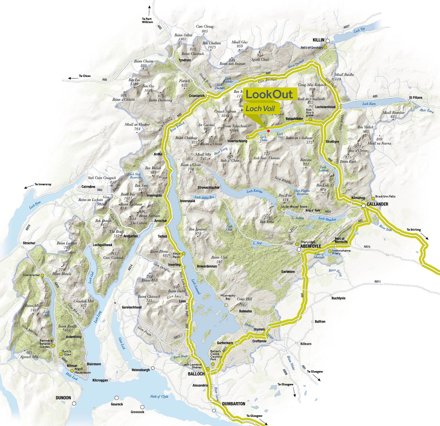
Loch Voil

This cabin, along with a wooden lookout, has mirrors that offer spectacular views of the landscape while reflecting the surroundings on its reflective surfaces.
Mirrored stainless steel was applied to birch sheets and fixed on the lookout’s exterior surfaces, creating constantly changing reflections and helping the structure blend into the environment.
Rob Roy MacGregor, an 18th-century Scottish patriot, folk hero, and outlaw, lived and died in Balquhidder, and his grave is in the local churchyard. This tranquil glen is dominated by the spectacular mountainous terrain of the Braes of Balquhidder at the head of Loch Voil. At the western end, the mountainous area north of Loch Katrine inspired Sir Walter Scott’s legendary poem "The Lady of the Lake."
As you approach Balquhidder, the north-south Strathyre Glen changes abruptly to the east-west glen that houses Loch Voil. In winter, Loch Lubnaig and Loch Voil sometimes flood to form a large lake known as "Loch Occasional." Balquhidder Glen is also popular for fishing, nature watching, and hiking in the surrounding mountains.
In Kilmahog, on the shores of Loch Lubnaig, Strathyre, Kingshouse, Balquhidder, and Lochearnhead, you will find places to eat and drink as well as picnic areas.
Falls of Falloch
John Kennedy designed ‘Woven Sound’ to offer a sheltered space where you can experience the Falls of Falloch from a closer perspective, providing a new viewpoint to appreciate the roaring beauty of the falls. This cantilevered structure, extending over the water’s edge, takes the form of a long trellis composed of intricately intertwined steel rods. This design integrates delicately among the existing trees to preserve the natural beauty of the surroundings, creating a sculptural and subtle form. The robust and economical steel material allows the shelter to blend discreetly into the environment without detracting from the magnificence of the falls. In the mottled steel of the lookout, an entry from Dorothy Wordsworth’s journal is inscribed, evoking the many Romantic writers and painters who visited the falls in the early 19th century.
The Falls of Falloch are a beautiful waterfall and a popular picnic spot. At 30 feet high, these falls mark a sharp drop in the course of the River Falloch as it descends through Glen Falloch towards Loch Lomond in Ardlui. The Falls of Falloch are a truly fascinating site located in a peaceful glen.
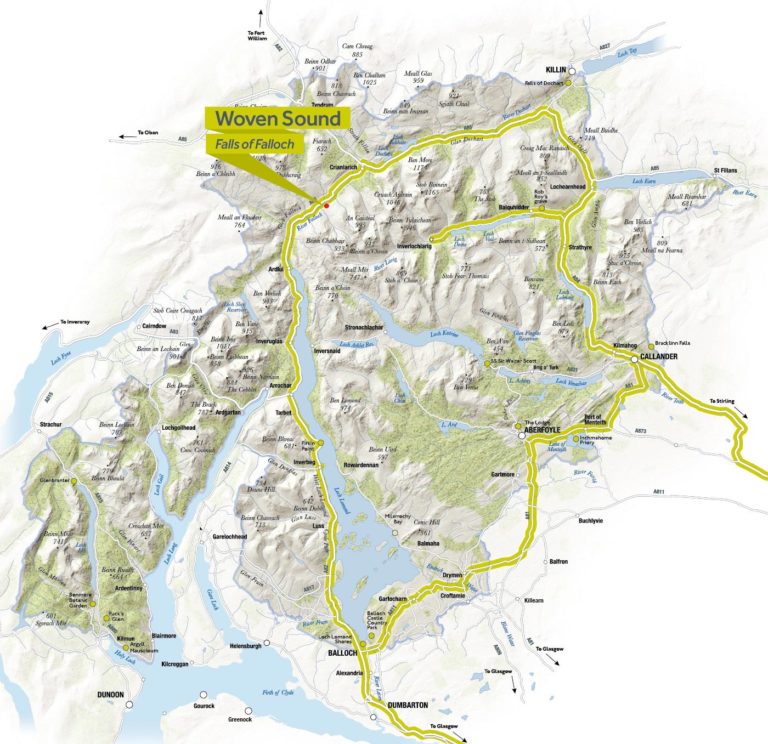
Photographic opportunities abound in the area. Further up in Glen Falloch, you can see the oldest remnants in the south of the ancient Caledonian pine forest and look for golden eagles and deer.
It’s important to note that parking at this site is limited, and during summer months and sunny days, it can fill up quickly. It is recommended to plan your visit in advance, arriving early in the day or considering visits during less busy periods to avoid disappointment. Parking on the A82 is dangerous and illegal, so it should be avoided.
Food and drink options can be found in Tarbet, Ardlui, Inverarnan, and Crianlarich, as well as designated picnic areas in Tarbet, Inveruglas, and Crianlarich.
The West Highland Way hike from Inverarnan to Crianlarich covers a distance of 6 1/2 miles (10.5 km), offering stunning views of the Falls of Falloch.
Loch Lubnaig Beag
Located among the shrubs in a natural hollow of the landscape, offering views from Loch Lubnaig to Ben Ledi.
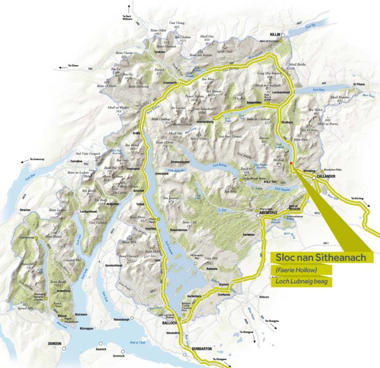
In Scottish Gaelic, ‘Sloc’ means ‘grassy hollow’, while ‘Sìtheanach’ refers to ‘fairy folk’, who according to our mythology inhabit places of peace and tranquility. The specialized metal carpentry found at your feet in this hollow features a verse from local bard Alexander Campbell.
“Now blows the wind of winter” describes man’s place in natural cycles and invites you to appreciate what surrounds you.
This is the perfect place to do just that.
Loch Lubnaig (which in Gaelic means "crooked lake"), 5 kilometers long, is situated between the pretty and lively town of Callander and Strathyre.
Once you have crossed the Highland Boundary Fault from Callander to Strathyre, you will experience a truly mountainous landscape. Beyond Kilmahog, the road twists and turns through the Pass of Leny, with waterfalls and rapids in the gorge below. You can observe a wide variety of woodland plants in the dappled shade beneath the surrounding trees. The steep, rugged slopes of Ben Ledi and Ardnandave Hill dominate the view from Lubnaig Beag.
Two new visitor sites are now open at the shores of Loch Lubnaig. At the larger of the two sites, closer to Strathyre, you can enjoy new barbecue stands, picnic benches, and toilets. Keep an eye out for the camping management zone in this area. Find available camping options at Loch Lubnaig.
An Ceann Mòr: Inveruglas
‘An Ceann Mòr’ in Inveruglas, along the shores of Loch Lomond, marks the culmination of the first phase of the Scotland Scenic Routes pilot project.
The path to the viewpoint begins at the visitor center car park, following a new accessible trail through the trees and then through the new structure, from where the panoramic view is revealed. Visitors can then ascend to the top of the viewpoint, sit and enjoy the stunning elevated views of Loch Lomond and the surrounding mountains. At eight meters high and pyramid-shaped, An Ceann Mòr is sure to be the focus of many photographs.
The viewpoint features 31 steps to the top, where you can enjoy a panoramic view of Loch Lomond.
Officially opened by Richard Lochhead MSP, Cabinet Secretary for Rural Affairs, Food, and Environment, on May 13, 2015, An Ceann Mòr was designed by the young architecture studio BTE, meeting the highest standards of accessibility and sustainability. Even people with limited mobility can access it through the “tunnel” to enjoy the stunning views, from the Arrochar Alps in the west to Ben Lomond in the distance.
Lochs that Form the National Park
Loch Chon
Surrounded by forests and offering wonderful views of the nearby hills and mountains, it is a dream location for outdoor enthusiasts. It is said that this sheltered body of water, located between Kinlochard and Inversnaid on the B829 secondary road, is home to a resident kelpie (water spirit) as well as one of the largest fairy populations in the world!

Loch Ard
Located in the Great Forest of Loch Ard and near the town of Aberfoyle, Loch Ard is a charming freshwater area stretching approximately 2.5 miles by one mile. It is rumored that the loch marks the birth of the River Forth, which continues its course to the sea, reaching the Firth of Forth on the east coast.
Three Lochs Forest Drive
Enjoy a unique journey through the forest, where history meets stunning landscapes and rich wildlife in the heart of Queen Elizabeth Forest Park.
The Three Lochs Forest Drive is a seven-mile (11.5 km) round trip that starts about two miles north of the popular town of Aberfoyle on the A821 known as the Duke’s Pass. This picturesque route was inaugurated 40 years ago, in 1977, to commemorate the Silver Jubilee of Queen Elizabeth II.
Lake of Menteith
The Lake of Menteith, known for being the only "lake" in Scotland rather than a "loch," is located in the Carse of Stirling near the town. Interestingly, and without a known reason, this small body of water was called the Lake of Mentieth until the 19th century.
Loch Arklet
Loch Arklet, situated in a fabulous and remote location, is worth a visit. From the town of Aberfoyle, follow the B829 road towards Inversnaid, passing first Loch Ard and then Loch Chon before finally reaching Loch Arklet. This loch lies east of the much larger Loch Lomond and west of Loch Katrine.
Loch Earn
Loch Earn is a long and narrow body of water situated on the eastern side of the National Park. This loch stretches 6.5 miles from west to east and forms the source of the River Earn. This river eventually joins the River Tay, Scotland’s longest river, in the village of Bridge of Earn in Perthshire.
Loch Eck
Loch Eck is a narrow stretch of water extending for seven miles and located on the Cowal peninsula, north of the town of Dunoon. It lies within the beautiful Argyll Forest Park, which is part of Loch Lomond and The Trossachs National Park.
Loch Goil
Loch Goil is a small sea loch situated on the western edge of the National Park. It forms an arm of Loch Long and a coastal section of the Cowal peninsula.
Holy Loch
Holy Loch is located at the southwestern edge of the National Park. The northern shore of this sea loch borders the protected area of the park and is approximately one mile wide and up to three miles long, depending on the tide.
Loch Katrine
Loch Katrine, within the national park, was the inspiration for Sir Walter Scott’s famous 19th-century poem "The Lady of the Lake" and continues to enchant visitors to this day. Additionally, Queen Victoria enjoyed a boat trip on this eight-mile-long loch in 1869.
Loch Long
Loch Long, located in the west of the National Park, is a sea loch extending 20 miles from the Firth of Clyde in its southwestern end. Similar to a fjord, the loch forms a long inlet with the coast of the Cowal peninsula on one side and the entire western coast of the Rosneath peninsula on the other side.
Loch Lomond
Loch Lomond, the largest inland stretch of water in Great Britain, is one of Scotland’s most popular destinations. Known for appearing in the famous song "The Bonnie Banks o’ Loch Lomond," this loch stretches north for 24 miles from Balloch, a highly visited gateway to the Highlands.
Loch Lubnaig
Loch Lubnaig is a freshwater stretch of water that, although small, is located in a stunning setting between two impressive mountains: Ben Ledi and Benvane to the southwest, and Ben Vorlich to the northeast. Viewing the loch from above or looking at a map, you can appreciate how it got its name, as "Lùbnaig" means "crooked" in Gaelic.
Loch Venachar
Loch Venachar is situated between the well-known tourist town of Callander and the small settlement of Brig o’ Turk. Along the southern shore of this six-kilometer-long loch stretches an extensive woodland area, which boasts a wide network of walking and cycling trails. A 4.5-mile hike reveals a hidden lochan among the trees.
Loch Voil & Loch Doine
Loch Voil and its smaller western neighbor, Loch Doine, are set in an area of stunning natural beauty and rich history. This area is part of the region known as Rob Roy Country, where many historical sites related to the infamous 17th-century Scottish outlaw Rob Roy MacGregor can be found. Rob Roy is a folk hero in Scotland, immortalized in Sir Walter Scott’s novel narrating his life.
Loch Iubhair & Loch Dochart
Lochs Iubhair (pronounced yoo-ar) and Dochart are connected by the River Dochart and lie in the impressive Glen Dochart. They are located on the north side of the A85 road when traveling east from Crianlarich.
Visiting Nearby Towns and Villages
Tyndrum
Tyndrum is a small village situated five miles north of Crianlarich, in the heart of the hiking area around Glen Lochy. It is an important transport hub, as the A82 road and the West Highland railway line branch from here to other parts of Scotland. Additionally, the famous West Highland Way passes through Tyndrum, making it a popular destination for hikers who traverse this route each year.
In Scottish Gaelic, Tyndrum is known as Taigh an Droma, which translates to "the house on the ridge."
Tarbet
Tarbet is a small village situated on the west shore of Loch Lomond, at the junction of the A82 and A83 roads. This small peninsula separates Loch Lomond from the sea and Loch Long.
Tarbet Pier is an important site for exploring the loch by boat. However, starting from January 29, the pier area will be completely closed for nine weeks due to regeneration works. During this time, there will be no access for pedestrians, cyclists, or parking for cars and motorhomes in the area. The grey and black water disposal point will also be closed during this period. Visitors are advised to plan ahead and find an alternative waste disposal point.
St. Fillans
St. Fillans is one of Scotland’s most charming villages, with stunning views of Loch Earn, a naturally beautiful setting, and a rich history. Located at the eastern end of Loch Earn along the A85 road, this picturesque village offers a perfect combination of stunning landscapes and historical connections.
The original settlement was known as Port of Lochearn or Meikleport in the 18th century. In 1817, Lord Gwydyr, husband of Clementina Drummond, heiress of the Drummond Estate, renamed it St. Fillans.
The Chapel of St. Fillan, a pre-Reformation church, and its graveyard are located south of the River Earn, between St. Fillans and the ancient Pictish fort of Dundurn. It is believed that St. Fillan, an Irish missionary, resided on this hill in the 8th century AD, where he joined the Gaels and Picts in spreading Christianity, playing a significant role in Scotland’s history.
The arrival of the railway between Crieff and Lochearnhead in the early 20th century transformed St. Fillans into a popular lakeside tourist destination. Many of the elegant stone houses with gabled roofs along the village’s main road date from that era, giving the place a sense of historical elegance.
Today, St. Fillans is a picturesque conservation village on the eastern edge of the National Park, offering visitors the opportunity to enjoy the natural beauty and serenity of the surroundings.
Port of Menteith
Port of Menteith is a small rural community located on the shores of Scotland’s only lake, the Lake of Menteith. The Lake of Menteith is notable for its contrast with the long and narrow lochs of the Trossachs, as it lies in the gentle glens of the Highlands. With its gently sloping shores, wooded islands, and ruined abbey, the lake offers a peaceful and tranquil perspective.
Surrounded by farmland and woods, the Lake of Menteith encapsulates the best of lowland scenery in the southern fringe of the National Park. Besides its scenic beauty, the lake is one of Scotland’s premier trout fishing spots and a wildlife sanctuary. During spring and summer, ospreys are a common sight, while in autumn and winter, the lake is a haven for a large number of geese.
In the center of the lake is the tranquil medieval priory on the wooded island of Inchmahome, accessible by a regular ferry service between Easter and October. This historic island houses an Augustinian monastery dating from 1238 and has been visited by kings and queens, including King Robert the Bruce and Mary, Queen of Scots.
The Lake of Menteith has a rich history, and it is known to have been significant to the Romans, who established a camp and a fort on the southwestern shore hundreds of years ago. With its natural beauty and rich heritage, Port of Menteith is a charming destination for visitors looking to experience the history and serenity of the Scottish Highlands.
Lochgoilhead
Lochgoilhead is a charming village situated on the northern shore of Loch Goil, on the Cowal peninsula in Scotland. This picturesque village offers stunning mountain and water landscapes, making it a popular destination for nature lovers and those seeking to escape the hustle and bustle of everyday life.
Surrounded by mountains, Lochgoilhead offers opportunities for fishing, birdwatching, and other outdoor activities. Loch Goil is a tranquil and serene spot that provides opportunities for boating, kayaking, and simply relaxing by the water.
In addition to its natural beauty, Lochgoilhead also has a variety of amenities for visitors, including cozy accommodations, local restaurants, and recreational activities. The village is an ideal starting point for exploring the surrounding region, including national parks and nearby historical attractions.
Lochearnhead
In Lochearnhead, visitors can enjoy a variety of outdoor activities such as hiking, cycling, and nature watching. The village’s natural surroundings offer numerous hiking routes that wind through forests, hills, and mountains, providing panoramic views of the area.
Additionally, Loch Earn is a popular destination for fishing, with an abundance of trout and salmon. Water sports enthusiasts will also find opportunities for sailing, windsurfing, and kayaking on the loch.
The history and heritage of Lochearnhead can be explored through visits to Edinample Castle and Ardvorlich House, which offer fascinating insights into the region’s tumultuous past.
Lochearnhead is a charming destination that combines natural beauty with rich history and a variety of outdoor activities for visitors to enjoy.
Killin
Killin, situated at the stunning Falls of Dochart, is a charming village with a rich history and breathtaking natural beauty. Its Gaelic name, Cill Fhinn, means "the White (or Fair) Church," reflecting its cultural heritage.
The village has strong ties with the MacNab clan, whose ancient burial ground is located on Inchbuie near the falls. Killin is also home to the prehistoric Killin Stone Circle and the ruins of Finlarig Castle, the historic stronghold of the Campbells of Breadalbane.
The Falls of Dochart are a prominent feature of Killin, with their impressive cascades offering a spectacular natural display. The River Dochart flows through the village, adding a unique and vibrant atmosphere. This natural setting makes Killin a popular destination for outdoor activities such as hiking, fishing, and water sports on Loch Tay.
Besides exploring Killin’s history and nature, visitors can enjoy a variety of short walks that offer panoramic views of the village and its surroundings. From the historic Finlarig Castle to the stunning Sron A’ Chlachain, there is something for all interests and skill levels.
An interesting curiosity is that the Tomnadashan Mine, an abandoned copper mine near the village, is rumored to have been the refuge of the Rabbit of Caerbannog from the famous movie "Monty Python and the Holy Grail."
Kilmun
Kilmun is a village rich in history and surrounded by stunning natural landscapes on the Cowal peninsula, on the shores of Holy Loch. Its Gaelic name, Cill Mhunna, reflects its monastic legacy established by the Celtic monk Saint Fintan Munnu in the 7th century.
Kilmun’s history is deeply intertwined with the presence of the Campbell clan, who established the collegiate church at the site of the existing parish church in 1442. This area became the traditional burial place of the Campbell chiefs. The adjacent private chapel, known as Kilmun Mausoleum, houses the tombs of many clan leaders.
Kilmun is also known for its fascinating forest and arboretum. The Kilmun Arboretum, established in the 1930s, features an impressive collection of 162 exotic tree species, making it a unique place in Scotland. Near the village, Puck’s Glen offers a spectacular walk through a magical gorge, with waterfalls, mosses, and ferns creating an enchanting setting.
Additionally, Benmore Botanic Garden, located north of Kilmun, is another highlight. With 120 acres of gardens, including an avenue of giant redwoods and an extensive collection of plants, it offers an impressive botanical experience amidst beautiful landscapes.
In terms of wildlife, Kilmun and its surroundings are home to a variety of species, from otters and eagles to deer and pine martens. The River Echaig and Holy Loch are particularly good spots for birdwatching, with a wide range of seabirds frequenting the area.
For those interested in exploring further, there are several local walks that offer panoramic views and the opportunity to immerse yourself in the natural beauty of the region. From Strone Hill to Beinn Mhor, there are options for all skill levels and preferences.
Kilmun is a fascinating destination that combines history, nature, and outdoor activities in a spectacular setting on the Cowal peninsula.
Crianlarich
Crianlarich is a curious village situated in Glen Strathfillan, in the heart of the stunning Scottish Highlands. With a strategic location about 8 miles north of Loch Lomond, it serves as an important crossroads and a vital stop for those exploring the central and northwestern routes of Scotland. Its Gaelic name, meaning "low pass," reflects its significance as a historic passage point.
The landscape surrounding Crianlarich is spectacular, with long glens, towering peaks, and swift streams cascading through the hills. This area is a treasure trove of biodiversity, with a wide range of habitats that host a variety of wildlife. From wetlands to open highland hills, the area is home to notable species such as the golden eagle, deer, peregrine falcon, and many more.
Crianlarich is also known for its Munros, with notable peaks like Ben More and Stob Binnein offering impressive panoramic views of the surroundings. These mountains are popular among hikers and nature enthusiasts looking to explore the majesty of the Scottish Highlands.
In addition to its natural beauty, Crianlarich is a place rich in history and culture. It has been an important stop since medieval times, and its role as a crossroads has endured through the centuries. Today, it remains a popular destination for travelers on the famous West Highland Line and the surrounding roads.
For visitors, Crianlarich offers the opportunity to explore a variety of scenic walks, from the Falls of Falloch to the snow-capped hills surrounding the village. There are also options to stop and enjoy the scenery at places like the Falls of Falloch, where you can admire the stunning views and immerse yourself in the serenity of the natural surroundings.
Crianlarich is much more than a crossroads; it is a destination in its own right, full of natural beauty, fascinating history, and opportunities for outdoor adventures.
Callander
Callander is a charming tourist town located in a beautiful natural setting, on the banks of the River Teith and on the A84 road, west of Stirling. Known as the gateway to the Scottish Highlands, it offers visitors their first experience of this stunning landscape. From cozy shops to delightful cafes, Callander has much to offer its visitors.
The town lies beneath high wooded cliffs and boasts a rich history dating back to Roman times. The Callander Pass, a distinctive landscape feature formed during the last ice age, has been a gateway between the lowlands and highlands of Scotland throughout history. The area is filled with interesting historical and geological sites, including clan burial grounds, Iron Age forts, and glacial erratics.
During the Victorian era, Callander flourished as a tourist destination thanks to the Romantic movement, attracting poets and writers who promoted its stunning scenery. Today, the town retains much of its historic character and remains a popular destination for tourists looking to explore the Scottish Highlands.
Visitors can enjoy a variety of scenic walks in the area, including the beautiful Bracklinn Falls and the trail to Callander Crags, which offers panoramic views of the town and beyond. There are also gentler routes, such as the Callander Meadows circuit, which follows the River Teith.
Callander is a delightful place to explore, with a unique blend of history, nature, and Scottish charm. From nature walks to quaint shops, there is something for everyone in this vibrant tourist town.
Balmaha
Balmaha is a charming village located on the eastern shore of Loch Lomond and is an important stop for hikers on the West Highland Way. The village also hosts the National Park Visitor Centre and serves as an ideal starting point for exploring Conic Hill and Inchcailloch Island.
Inchcailloch Island played a crucial role in Balmaha’s history. Saint Kentigerna arrived on the island in 717 AD and settled there until her death several years later. The island, named "the island of the old/hooded woman" in Gaelic, was an important religious center, with a church that became the local parish’s focal point. Inchcailloch was also a burial site for the MacGregors, including the ancestors of Rob Roy.
In Balmaha and its surroundings, there are a wide variety of activities to enjoy. The famous Conic Hill offers spectacular views of Loch Lomond and its islands, and the National Park Visitor Centre is an excellent source of information about local wildlife, geology, and history. Visitors can also explore Inchcailloch by taking a water bus from MacFarlane’s Boatyard and spending the night camping on the island.
Additionally, water bus services from Balmaha offer the opportunity to explore other areas of Loch Lomond, such as the picturesque village of Luss on the western shore. Balmaha is a charming destination for those looking to enjoy the natural beauty and rich history of the Scottish Highlands.
Balloch
Balloch, located on the southern shore of Loch Lomond, is a destination accessible from Glasgow and the central belt of Scotland. The name "Balloch" comes from the Gaelic "bal," meaning "village or hamlet," translating to "village on the loch," referring to nearby Loch Lomond.
The village features a lively main street with supermarkets, gift shops, cafes, bars, and restaurants. Historically, Balloch was an important gateway for boats entering Loch Lomond during the 19th century.
One of Balloch’s highlights is Balloch Castle Country Park, which was home to the Earls of Lennox in medieval times. Although the old castle no longer stands, the park offers stunning landscapes and views of the loch from the prime location of the Gothic mansion built in 1808.
Loch Lomond is a major attraction in Balloch, where visitors can enjoy boat trips, lakeside walks, and a variety of water activities. Loch Lomond Shores is another popular spot offering leisure experiences, shopping, and impressive views of the loch.
For families, Balloch offers a wide range of activities such as the TreeZone aerial adventure course, the Loch Lomond Bird of Prey Center, and the Loch Lomond Sea Life Aquarium. There are also options to rent bikes and boats at Loch Lomond Shores beach.
Cycling and hiking enthusiasts will find plenty of routes to explore, including the West Loch Lomond cycle path and National Cycle Route 7, offering panoramic views of the surrounding landscape.
Despite its northern latitude, Balloch enjoys a milder climate than places like Moscow, making it an attractive destination year-round.
Ardentinny
Ardentinny, situated on the western shore of Loch Long on the Cowal peninsula, is a small coastal village with spectacular scenery that makes it truly special within the National Park.
Beginnings as a Ferry Crossing: Over the years, Ardentinny has been an important place for travelers. From the Iron Age to the present, it has served as a ferry crossing to Coulport on the eastern shore of Loch Long, bringing the Cowal peninsula and Argyll closer to the Scottish lowlands. Although the ferry is no longer in operation, its history is preserved in places like Ferry Cottages and the Ardentinny Hotel, which date back to the 19th century.
Trails: Ardentinny offers several walking trails that wind through the coast and surrounding forests. These trails, once reserved for local foresters, are now accessible to visitors. An 11-kilometer hike will take you to Carrick Castle, while near the parking area is the Glenfinart Walled Garden, a community garden that used to be the orchard of Glenfinart House.
Beach Life: With a sandy beach that is the longest on the Cowal peninsula, Ardentinny offers beautiful views of Loch Long. The coastline is rich in wildlife, with marine creatures such as seals, porpoises, and seabirds like guillemots and gannets. Crabs and sea anemones can also be found in the exposed rock pools.
The name "Ardentinny" translates from Gaelic as "hill of fire" or "Beacon Hill," suggesting the historical importance of the location as a landmark or signaling point for travelers.
Luss
The pretty village of Luss is located on the shores of Loch Lomond, just a short drive north of Balloch and south of Tarbet. With a history dating back to medieval times, much of the village seen today was created in the 18th and 19th centuries to house workers from nearby slate quarries. In spring and summer, the village comes alive with elaborate floral displays, attracting visitors heading to the lakeshore. A visit to Luss is not complete without taking in the view from the pier, with the majestic Ben Lomond dominating the landscape over Loch Lomond.
History and Heritage: Around 1,500 years ago, the Irish missionary Saint Kessog brought Christianity to the area, and Luss, then called Clachan Dhu (the dark village), got its current name due to the herbs growing on his grave. The current church, built in 1875, stands on an ancient graveyard that houses tombs dating back to the 7th or 8th century, including an 11th-century Viking grave.
The Luss Hills and Loch: The surrounding Luss Hills offer spectacular views and are popular among hikers. Their conical peaks, curved ridges, and birch-filled ravines contribute to the area’s stunning landscape. From the pier, visitors can embark on lake cruises and explore nearby islands, as well as connect with other locations such as Balloch, Inchcailloch, and Balmaha.
Village Walks: Luss offers four short walks that allow visitors to explore the village and its surroundings, from the picturesque lakeside walk to the trail passing by old mills and slate quarries.
Curiosity: The village of Luss was used as the set for the soap opera "High Road," which contributed to its popularity during the 80s and 90s.
With its historical charm and stunning natural setting, Luss is a must-visit destination for those exploring Loch Lomond.
Drymen and Gartocharn
Just south of Drymen, Gartocharn is nestled under Duncryne Hill, locally known as "The Dumpling" for its peculiar shape. With a population of around 700, Gartocharn retains its rural character while enjoying proximity to modern amenities. Here, you can find impressive historical remnants such as Ross Priory, a 17th-century Gothic mansion where Sir Walter Scott wrote parts of his works. Additionally, the surroundings of Gartocharn offer opportunities for birdwatching at RSPB Loch Lomond and panoramic views from the summit of Duncryne Hill.
Exploration and Activities: Both villages offer a variety of outdoor activities and trails to explore the beauty of the Scottish Highlands. From hikes along the West Highland Way to walks on local trails surrounding the villages, there is something for all skill levels and preferences. Football enthusiasts can enjoy local league games during the summer season in Drymen. For a more relaxed experience, visitors can take walks along the shores of Loch Lomond and observe the diverse wildlife at the RSPB Loch Lomond nature reserve.
Drymen and Gartocharn offer a unique combination of history, picturesque landscapes, and outdoor activities, making them must-visit destinations in the Scottish Highlands.
Waterfalls within the park
Inversnaid
Inversnaid, whose Gaelic name means ‘The mouth of Allt na Snàthaid,’ is a stunning destination that offers an authentic experience amidst the natural beauty of the Scottish Highlands.
Inversnaid Falls: The Inversnaid Falls are a natural wonder located a short distance south of the hotel. Access is easy, and a path leads to a bridge over a tranquil pool where the Arklet Burn forms an impressive waterfall cascading into Loch Lomond. This spot inspired the poet Gerald Manley Hopkins, who immortalized the beauty of the falls in his poem ‘Inversnaid,’ celebrating the importance of wetness and wildness in the world.
Getting There: Inversnaid is accessible by both public transport and car. From Glasgow and central Scotland, you can take a Citylink bus that operates several daily trips of approximately 1 hour and 10 minutes to Tarbet. From there, a water bus can take you to Inversnaid. Alternatively, you can take a train to Arrochar & Tarbet station and then a water bus from Tarbet to Inversnaid.
If you prefer to drive, from Glasgow take the A81 passing through Milngavie and Strathblane, following signs to Aberfoyle. From Edinburgh and Perth, head towards Stirling on the M9, then take the A84 to Callander and the A873 to Aberfoyle. From Aberfoyle, take the B829 road which will lead you past Loch Ard, Loch Chon, and finally to Inversnaid.
Natural Exploration: Once in Inversnaid, enjoy the tranquility of the natural surroundings. Explore nearby trails to discover more natural beauty and immerse yourself in the serene atmosphere surrounding the falls and Loch Lomond. Inversnaid offers a unique opportunity to connect with nature and experience the majesty of the Scottish Highlands at their finest.
Falls of Falloch
The Falls of Falloch, known in Gaelic as Eas Falach, offer an impressive spectacle amid the serene beauty of the Scottish Highlands. This site, significant for both its natural beauty and cultural importance, is an ideal destination for a peaceful picnic by the river.
Highlights: The falls are located just a few steps from the A82, making them a convenient stop for travelers heading north. The natural setting is perfect for a relaxing picnic, where you can enjoy the comforting sound of the water while soaking in the tranquil atmosphere.
In addition to their natural beauty, the Falls of Falloch are also a paradise for expert kayakers seeking thrills in the river’s turbulent waters. Here, they can challenge the currents and enjoy the excitement of navigating an exhilarating and stimulating river stretch.
Art and Nature Intertwined: In addition to their natural appeal, the Falls of Falloch also host an art installation called ‘Woven Sound.’ This project, part of Scotland’s Scenic Routes, was created in 2013 to enhance visitors’ experience of the Scottish landscape. Here, visitors can marvel at the integration of art and nature while immersing themselves in the surrounding beauty.
Getting There: To reach the Falls of Falloch by car from Glasgow, simply follow the A82 north for approximately 52 miles, passing Loch Lomond. After passing Inverarnan, you will see signs to the falls on the right. Although there is no public transport available, the convenient location makes it easily accessible for travelers driving through the region.
The Falls of Falloch offer a unique opportunity to experience the majesty of Scottish nature and enjoy a moment of serenity amid the hustle and bustle of daily life.
Puck’s Glen
A wonder on the Cowal peninsula, Puck’s Glen leads through dark, moss-covered forests in Argyll Forest Park. This hidden gem offers an unforgettable experience with dozens of waterfalls, stunning viewpoints, and lush vegetation that will leave you in awe.
Highlights: Puck’s Glen is a paradise for nature lovers and adventure seekers. On this short circuit of less than 2 hours, you will find yourself surrounded by a magical atmosphere as you walk alongside the descending stream, discovering hidden waterfalls and immersing yourself in the lush forest vegetation.
As you progress along the trail, you will witness a series of waterfalls dotting the landscape, creating a symphony of relaxing sounds that accompany your walk. Additionally, you will have the opportunity to enjoy spectacular viewpoints offering panoramic views of the surroundings, as well as the numerous rhododendrons that adorn the landscape with their vibrant colors.
Getting There: To reach Puck’s Glen, you have several transportation options:
- Public Transport: From Glasgow, you can take a train to Gourock station and then the Argyll Ferries ferry to Dunoon. From there, you can take the 489 bus service (West Coast Motors) to Benmore Botanic Gardens, where the Puck’s Glen trail begins.
- By Car and Ferry: If you prefer to drive, you can reach Puck’s Glen by taking the Western Ferries ferry from McInroy’s Point to Hunters Quay. From there, follow the signs to Botanic Gardens on the A815, where you will find the trailhead. You can also arrive by road, taking the A82 towards Loch Lomond and then the A83 at Tarbet, before switching to the A815 at Strachur.
Regardless of your chosen mode of transport, once you arrive at Puck’s Glen, a magical and fascinating experience awaits you, taking you through one of Scotland’s most enchanting corners. Don’t miss it!
Falls of Dochart
The Falls of Dochart in Killin are impressive, offering a captivating natural spectacle.
Known in Gaelic as Eas Dochart, these falls provide a spectacular view as the River Dochart cascades over rocks, creating a scene worthy of admiration.
Highlights: The Falls of Dochart are an iconic feature in Killin, with their powerful flow of water spilling over rocks and surrounding the picturesque island of Inchbuie. These falls offer an impressive display at any time of the year, but they are especially striking when the water level is high and the river is in full flow.
One of the most fascinating aspects of the Falls of Dochart is their easy access. From the nearby bridge, visitors can enjoy a privileged view of the falls and watch the water rush forcefully over the rocks. However, it is recommended to be cautious of traffic, as the bridge can be busy, especially during peak tourist periods.
Getting There: To reach the Falls of Dochart in Killin, you have several transportation options:
- Public Transport: During the summer, several bus services pass through Killin, including Citylink services 913, 973, and 978, which operate from different cities like Edinburgh, Dundee, and Fort William. There is also a local bus service, Kingshouse Travel C60, that runs from Callander to Killin.
- By Car: From Glasgow, you can reach Killin by following the A82 north and then switching to the A85 at Crianlarich. Another scenic route is to take the M80 out of Glasgow and then switch to the A84 at Stirling, before heading towards Callander and finally arriving at Killin. From Edinburgh, take the M9 to Stirling and then follow signs to Callander and Killin.
- By Bicycle: If you prefer to travel by bike, National Cycle Route 7 passes through Killin, offering a scenic way to explore the area while enjoying the Trossachs’ landscape.
Bracklinn Falls
The Bracklinn Falls captivate the senses, surrounded by lush vegetation and incredible landscapes. Known in Gaelic as A’ Breac Linn, meaning "speckled pool," these falls are a popular destination for both local residents and visitors seeking to explore the natural beauty of Scotland.
Highlights: The Bracklinn Falls are an impressive spectacle of moving water, where a beautiful flow of water rushes between large rock blocks, creating a serene and majestic environment. Surrounded by lush vegetation and forests, these falls offer a tranquil retreat where visitors can enjoy nature’s beauty at its finest.
Access and Tips: Currently, work is being carried out to replace the bridge at Bracklinn Falls. During this period (December 2021 – January 2022), residents and visitors are advised to avoid the area. However, you can find suggestions for alternative walks in the Callander area and other places in the National Park on the official website.
To reach Bracklinn Falls, you have several transportation options:
- Public Transport: The best way to get to Callander is to take a bus from Stirling. You can check bus schedules online to plan your trip.
- By Bicycle: National Cycle Route 7 runs through the National Park and passes through Callander, offering an opportunity to explore the area by bike while enjoying the Trossachs’ scenery.
- By Car: From Glasgow or Edinburgh, the drive to Bracklinn Falls is quick and convenient, with a travel time of approximately 1-1.5 hours, depending on traffic and road conditions.
It is important to note that the route currently shown by Google Maps to reach Bracklinn Falls by car is incorrect. The correct route is to turn off Callander Main Street onto Bracklinn Rd and continue to Bracklinn Falls Car Park, from where you will need to walk an additional kilometer to reach the falls.
Beinglas Falls
The Beinglas Falls, whose Gaelic name translates to "The Green Mountain," are an impressive natural feature located near the adjacent mountain Ben Glas. In Gaelic, they are known as Eas na Beinne Glaise.
These falls, approximately 300 meters (1000 feet) high, offer a remarkable view that can be clearly enjoyed from the A82 road and from the Drover’s Inn, located a few hundred meters away. To reach them, you need to pass through Beinglas Campsite and ascend a path for about 30 minutes, following the same route that eventually leads to Beinn Chabhair, one of the 21 Munros in the park. The path is steep and challenging, but the roar of the water heard before the falls come into view indicates that the effort is worth it.
To access Beinglas Falls by public transport, the most practical option is to start from Inverarnan, near the Drover’s Inn. Although there is no designated bus stop at this point, drivers often drop off passengers. However, returning can be a bit more complicated, as you will need to reach Crianlarich or Ardlui to take the bus or train, both a few kilometers away. Another option is to follow the route to An Caisteal from Crianlarich.
By car, from Glasgow, take the A82 north for 52 miles, passing Loch Lomond, until you reach Inverarnan, where the falls are located.
Falls of Leny
The Falls of Leny, known in Gaelic as Eas Lànaigh, offer an impressive view surrounded by lush trees with branches extending over them. The Pass of Leny, Cumhang Llanaigh in Gaelic, traverses this landscape, while the river flowing here is the Garbh Uisge, meaning "boisterous river."
The best way to admire the falls is from National Cycle Route 7, which makes for a pleasant walk from Callander or a shorter walk from the busy Ben Ledi car park (early arrival is recommended due to its popularity). They can also be accessed from the Kilmahog car park, which has a link path to National Cycle Route 7. This site is very popular among competent and experienced kayakers and offers a particularly impressive spectacle after heavy rains.
To reach the falls by public transport, there are no direct options, but you can walk approximately 4 km from Callander to reach them. By car, the Falls of Leny car park is located on the A84, approximately 4 km west of Callander.