Caldera de Taburiente National Park is a protected area located on the island of La Palma, in the autonomous community of the Canary Islands, Spain. Like the rest of the archipelago, its origin is volcanic, but it is distinguished by the abundance of water resources, both underground and surface.
Content
- 1 Characteristics of the Caldera de Taburiente National Park
- 2 Flora of the Caldera de Taburiente
- 3 Fauna of the Caldera de Taburiente
- 4 Recommended Excursions and Activities
- 5 What to See and Do in Caldera de Taburiente National Park
- 5.1 Roque de los Muchachos
- 5.2 Colored Waterfall in Barranco de las Angustias
- 5.3 Lomo de las Chozas Viewpoint
- 5.4 Bejenado Peak, La Palma
- 5.5 Taburiente Beach
- 5.6 Roque de los Muchachos Astrophysical Observatory
- 5.7 El Paso Visitor Center
- 5.8 Camping Area in Caldera de Taburiente
- 5.9 Hiking Trails in Caldera de Taburiente
- 6 How to Get to Caldera de Taburiente National Park
Characteristics of the Caldera de Taburiente National Park
Establishment of the national park
On October 6, 1954, the Caldera de Taburiente was declared a national park, becoming the second area in the Canary Islands to receive this designation, after Teide National Park in Tenerife, and the fourth national park in all of Spain. Additionally, since 2002, the entire island has been recognized as a World Biosphere Reserve. The park covers an area of 46.9 km², which, together with the Peripheral Protection Zone, adds up to a total of 59.56 km².
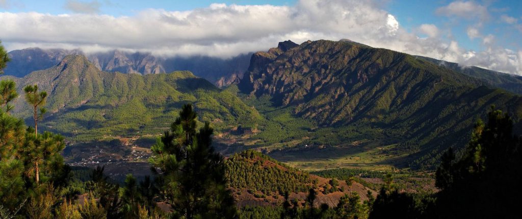
The park is located in the center of the island, coinciding with the Taburiente depression, which has a maximum axis of 7 km. This area is considered one of the most representative natural attractions of La Palma. The caldera is located between 600 and 900 meters above sea level, while the ridge that surrounds it reaches 2,426 meters at its highest point, known as Roque de los Muchachos, where the famous Roque de los Muchachos Observatory is located.
Objectives of the protected area Caldera de Taburiente
One of the main management objectives in the Caldera de Taburiente National Park is the implementation of genetic rescue programs for endangered species in the area, due to the large number of endemic species present, many of which are at risk.
Origin of the park’s name
The term "caldera" translates to "cauldron" in English. "Taburiente" is not a Spanish word; it comes from the Guanche language and means "plain, leveled."
Geology
The formation of the caldera is due to the existence of a large crater where lava, upon cooling, produces basaltic rocks. Eruptions in this type of calderas are generally calm, forming lava flows that expand the volcano more in surface than in height. As the lava cools in the crater, its weight can cause the formation of a secondary cone within or next to the caldera.

The rapid cooling of the lava can increase pressure and cause explosive eruptions, although another evolutionary process of a caldera involves the rapid spill of lava within the crater. This spill can create a breach in the crater wall or its upper edge, as seems to be the case with the Caldera de Taburiente. This process is similar to that observed in the volcanoes of the Galapagos Islands.
Its formation dates back about 2 million years. Fluvial erosion occurred after the lava spill, as it alone could not have created such a large scar on the island. The erosion would have produced a beach of detrital materials, which is not observed here. At the beginning of the Barranco de las Angustias, the last tributaries drain towards the center of the caldera, something that cannot be explained by an explosive eruption.
Geography
This region of the island of La Palma in the Canary Islands, called Caldera de Taburiente, has a diameter of approximately 10 km, with walls that in some places rise 2,000 m above the caldera floor. The highest point is Roque de los Muchachos, located on the northern wall, with an altitude of 2,426 meters and accessible by road. La Cumbrecita is at a lower point on the southeastern edge of the caldera. In the southwest, the caldera opens to the sea through the Barranco de las Angustias. La Cumbre Nueva is a ridge that begins in the caldera and extends southwards. The formation of the caldera dates back about 2 million years, originating from a large shield volcano about 20 km in diameter. However, the caldera was not formed by a volcanic explosion, but by erosion that began in the original crater of the volcano.
IUGS Geological Heritage Site
Due to its importance in the study of volcanology, the "Volcanic Caldera of Taburiente" was included by the International Union of Geological Sciences (IUGS) in its set of 100 ‘geological heritage sites’ in the world, according to a list published in October 2022. The IUGS defines an ‘IUGS Geological Heritage Site’ as ‘a key place with geological elements and/or processes of international scientific relevance, used as a reference, and/or with a substantial contribution to the development of geological sciences throughout history’.
Hydrography

The park is notable for its wealth of water. Numerous springs emerge, forming rivers, streams, and waterfalls, such as the Salto de la Desfondada, with a drop of about 150 meters. The waters are mostly clean and clear, although some are altered in their composition by materials like iron, giving the Río de Almendro Amargo a yellow-reddish color. The main hydrological basins are those of Taburiente and Almendro Amargo, which converge in the Barranco de las Angustias, the only natural outlet of the Caldera to the sea.
Since 1557, the Caldera has been owned by the Community or Heredad de las Haciendas de Argual y Tazacorte, maintaining its value and attraction to this day.
Tourism
Of the four national parks in the Canary Islands, the Caldera de Taburiente currently receives the fewest visits, after Teide in Tenerife, Timanfaya in Lanzarote, and Garajonay in La Gomera. Nationally, it is the ninth most visited park, with 445,084 visitors in 2015, behind parks like El Teide, Guadarrama, Picos de Europa, Timanfaya, Sierra Nevada, Garajonay, Ordesa y Monte Perdido, and Aiguas Tortas y Lago de San Mauricio.
Historical populations in the Caldera de Taburiente

During the Spanish conquest of the Canary Islands in the 15th century, the Caldera de Taburiente was the last refuge of resistance for the indigenous people of the archipelago, a branch of the Guanches known as the Benahoaritas. This place proved to be impregnable for the Spanish invaders, who only managed to defeat the Benahoaritas by luring their leader under the pretext of engaging in conversations.
In 1815, the German geologist Christian Leopold von Buch visited the Canary Islands. During his stay in Tenerife, he was taken to the Caldera de las Cañadas. Later, he visited La Palma, and in his diary, he clearly distinguished between a volcanic caldera and the erosive origins of the Caldera de Taburiente. After returning to Germany, von Buch published his diary and introduced the term "caldera" into the geological vocabulary.
Influence in arts and sciences
In the 1830s, the caldera inspired various works of art that combined the study of geology with botany, such as the works of Sabin Berthelot and Felix-Achille St. Aulaire. These works reflect the impressive combination of geological diversity and botanical richness of the place, highlighting the importance of the Caldera de Taburiente in both scientific and artistic fields.
Flora of the Caldera de Taburiente
The dominant species in the park is the Canary Island pine (Pinus canariensis), known for its ability to withstand fires thanks to a millennia-old adaptation to fires caused by volcanic eruptions: its bark burns, but the tree remains alive internally. Alongside the Canary Island pine, there is the amagante (Cistus symphytifolius), an endemic species of the Canary Islands that thrives in poor volcanic soils.

Other species of rockrose (Cistus monspeliensis) also grow, under which the parasitic plant called batatilla or vaquita (Cytinus hypocistis) can be found. Within the caldera, the laurel forest, composed of faya and heather, forms a green forest crucial to the ecosystem as it acts as a condenser of mist and provides water to the soil. Among the most notable species are the faya (Myrica faya) and the heather (Erica arborea).
In the ravines, where humidity is higher, remnants of laurel forests with species such as the acebiño (Ilex canariensis), laurel (Laurus azorica), barbusano (Apollonias canariensis), viñátigo (Persea indica), and marmolán (Myrsine canariensis) can be found. Other common species include the Canary willow (Salix canariensis), tajinaste (Echium), common fern (Pteris aquilina), bejeque (Aeonium, Greenovia, Aichryson), tabaiba (Euphorbia), and verodes (Senecio kleinia).
At over 1700 meters altitude, you can find the codeso (Adenocarpus viscosus), the Canary Islands juniper (Juniperus cedrus), the mountain violet (Viola palmensis), the blue tajinaste (Echium gentianoides), and the retamón (Teline benehoavensis).
Fauna of the Caldera de Taburiente

The park’s fauna is mostly composed of arthropods, especially insects, many of which have not yet been fully studied. Among the most notable arthropods are the centipede, which can reach almost a span in length, and the wolf spider. At 2000 meters altitude, there is a cave inhabited by a cave beetle endemic to La Palma, which has lost its eyes and pigmentation.
The vertebrate fauna is limited, with most species being introduced, except for bats, some amphibians, reptiles, and fish. Among the mammals are the Barbary sheep, goats, rabbits (which threaten endemic plants), feral cats, and several species of bats such as the long-eared bat, the Canary long-eared bat, the mountain bat, and the common bat.
Birds in the park include the kestrel (Falco tinnunculus canariensis), the rock dove (Columba livia canariensis), the laurel pigeon (Columba junoniae), the chough (Pyrrhocorax pyrrhocorax barbarus), the raven (Corvus corax tingitanus), the blackbird (Turdus merula agnetae), the blue tit (Parus caeruleus palmensis), and the blackcap (Sylvia atricapilla atricapilla).
Among the amphibians are the Mediterranean tree frog (Hyla meridionalis) and the common frog (Pelophylax perezi). Reptiles include Delalande’s wall gecko (Tarentola delalandii) and the Tenerife lizard (Gallotia galloti).
Recommended Excursions and Activities
What to See and Do in Caldera de Taburiente National Park
Roque de los Muchachos
Roque de los Muchachos, the highest point on the island of La Palma at an altitude of 2,426 meters, offers beautiful views of the park and the island. It is a popular destination for hikers and can be accessed by car. This peak also hosts one of the most important astronomical observatories in the world.

Colored Waterfall in Barranco de las Angustias
The Cascada de Colores is a picturesque waterfall located in the Barranco de las Angustias. Its name comes from the yellow, orange, and green hues formed due to the minerals present in the water. This natural phenomenon is a popular attraction for hikers exploring the ravine.
Lomo de las Chozas Viewpoint

Mirador Lomo de las Chozas offers an impressive panoramic view of the Caldera de Taburiente. From this viewpoint, visitors can admire the volcanic landscape and vegetation that characterizes the park. It is an ideal spot for photography and to enjoy the tranquility of the natural surroundings.
Bejenado Peak, La Palma

Pico Bejenado, with a height of 1,854 meters, is a prominent volcanic peak in La Palma. It offers hiking routes that lead to its summit, from where spectacular views of the caldera and the rest of the island can be obtained. It is an ideal place for nature and adventure lovers.
Taburiente Beach

Playa de Taburiente, located within the Caldera de Taburiente, is not a conventional beach but an area by the river with small natural pools. It is a perfect place to rest and enjoy the serenity of the water and natural surroundings after a hike through the park.
Roque de los Muchachos Astrophysical Observatory

The Roque de los Muchachos Astrophysical Observatory is one of the most important astronomical observation centers in the world. Located at the top of Roque de los Muchachos, this observatory takes advantage of La Palma’s ideal atmospheric conditions to study the universe, making it a reference point in scientific research.
El Paso Visitor Center

The El Paso Visitor Center provides detailed information about the history, geology, flora, and fauna of Caldera de Taburiente National Park. It is the ideal starting point for visitors who want to learn more about the park and plan their visit, offering exhibitions, maps, and guides.
Camping Area in Caldera de Taburiente
The camping area within Caldera de Taburiente National Park is a unique opportunity to experience the rugged nature of La Palma. Located amidst large pines, it is the only place to stay within this natural area. The island’s flora and fauna are safe, making camping under the open sky a refreshing and worry-free experience.
Stays are free, but prior reservation is required. Access is via a 5.5-kilometer trail from Los Brecitos to the Taburiente stream. The area has wooden tables, running water, and restroom facilities, as well as surveillance staff. Nearby is the Taburiente service center, a circular building that provides information about the trails and natural values of the park.
Hiking Trails in Caldera de Taburiente
Caldera de Taburiente National Park can only be explored on foot, with an extensive network of well-marked and maintained trails.
The network includes the long-distance GR-131 trail, which circles the caldera and reaches the summit of La Palma at Roque de los Muchachos, 2,426 meters above sea level. Additionally, there are multiple variants of the short trail PRLP-13, which cross ravines with streams and are covered by pines. One of the most popular trails descends zigzagging from Los Brecitos to the winding Barranco de las Angustias, offering a unique experience in contact with the island’s nature.
How to Get to Caldera de Taburiente National Park
To access the park, visitors have two main points: the La Cumbrecita viewpoint, just 15 minutes by car from the El Paso Visitor Center, and Los Brecitos, an hour from Los Llanos de Aridane. It is crucial to reserve parking if you plan to arrive before 4:00 PM.
The main information point about Caldera de Taburiente National Park is the Visitor Center, located in the municipality of El Paso. It is at kilometer point 23.900 of the LP-2 regional road, which connects Santa Cruz de La Palma, the island’s capital, with Los Llanos de Aridane, another important urban center on the island.
Access by Public Transport
The Visitor Center is accessible by the guagua (bus) service. The line connecting Santa Cruz de La Palma with Los Llanos de Aridane has a stop in the Visitor Center parking lot, making access easy for those using public transport.
Access to La Cumbrecita Viewpoint
From the Visitor Center, there is a road leading to the La Cumbrecita Viewpoint, a 7 km journey. This viewpoint is one of the most visited spots in the park and has an information booth. In the mornings, vehicle access is regulated from the Visitor Center to avoid congestion.
Access to Roque de los Muchachos Viewpoint
To reach the Roque de los Muchachos Viewpoint, you can go from Santa Cruz de La Palma via the LP-1032 road towards the Astrophysical Observatory or from Los Llanos de Aridane via the LP-1 and LP-113 roads. In both cases, you need to reach the residence intersection and turn towards the highest point of the park and the island, Roque de los Muchachos. There is also an information booth here. There is no regular transport service on this road, so access must be made through organized trips, taxi, or rental car.
Access to Brecitos Viewpoint
To access the Brecitos Viewpoint and the interior of the Caldera, you must reach Los Llanos de Aridane and follow the signs to the Los Barros road, which leads to the national park. In this area, there is an information booth and a 13 km track leading to Brecitos. Although you can drive up, parking is not allowed in Brecitos. For those who want to walk through the park, there are two options:
- With a private vehicle to Brecitos.
- Using a private taxi service available in the Barranco de las Angustias parking lots, which take visitors to Brecitos to complete the route from Brecitos to Angustias. Schedules vary depending on the time of year: in summer from 8:30 AM to 1:30 PM and in winter from 9:00 AM to 12:00 PM.
Accessibility for People with Disabilities
The National Park presents certain access difficulties for people with disabilities, allowing access only to the La Cumbrecita and Roque de los Muchachos viewpoints. However, groups with disabilities (such as vision loss) have been seen accessing the camping area to spend the day or overnight. It is recommended to contact the staff of the San Antonio de El Monte hostel in Garafía, who often organize activities for groups with disabilities (phone numbers: 922-400-444 and 696-968-255).
The El Paso Visitor Center is equipped with facilities to facilitate access for people with disabilities, providing an inclusive environment for all visitors.